 Lýsigagnagátt
dataset
Type of resources
Available actions
Topics
INSPIRE themes
Keywords
Contact for the resource
Provided by
Years
Formats
Representation types
Update frequencies
status
Scale
Resolution
-

Í gögnunum er að finna upplýsingar um staðsetningu og umfang friðlýstra minjasvæða á Íslandi sem Minjastofnun Íslands hefur friðlýst í samræmi við lög nr. 80/2012 um menningarminjar.
-
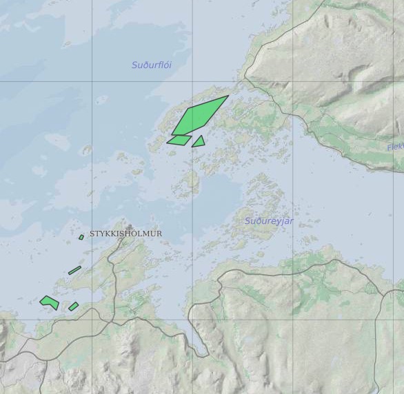
Ræktunarsvæði er afmarkað svæði sjávar nægjanlega stórt til að rúma þann ræktunarbúnað sem notaður er á viðkomandi svæði. Yfirleitt er um að ræða línur sem strekktar eru á milli flot bauja eða sérstaka ræktunarfleka með lóðréttar ræktunarlínur fáeina metra niður undir yfirborð sjávar . Svæðið er merkt með löglegum sjómerkjum þannig að sjófarendur eiga að geta varast þau, enda einnig merkt inn sjókort Landhelgisgæslunnar. Einungis er ræktuð Bláskel (Kræklingur).
-

Riparian zones represent transitional areas occurring between land and freshwater ecosystems, characterised by distinctive hydrology, soil and biotic conditions and strongly influenced by the stream water. They provide a wide range of riparian functions (e.g. chemical filtration, flood control, bank stabilization, aquatic life and riparian wildlife support, etc.) and ecosystem services. The Riparian Zones products support the objectives of several European legal acts and policy initiatives, such as the EU Biodiversity Strategy to 2020, the Habitats and Birds Directives and the Water Framework Directive. Green Linear Elements (GLE) are ecologically significant, structural landscape elements which act as important dispersion vectors of biodiversity. GLEs comprise hedgerows and lines of trees and offer a wide range of ecosystem services: they are linked to both landscape richness and fragmentation of habitats, with a direct potential for restoration, and contribute also to hazard protection. Green linear elements form part of the Green Infrastructure and are specifically addressed in the EU Biodiversity Strategy 2020. The GLE product provides reliable and detailed geospatial information on the occurrence and spatial distribution of: Small linear vegetation features such as hedgerows, scrub and tree rows with a minimum length of 100m and a width of up to 10m; Isolated patches of trees and scrub with a size between 500 m² and 0.5 ha. Green linear elements including trees and hedgerows with 100m minimum length and 500 m² Minimum Mapping Unit (MMU)
-
Vinsamlega hafið samband við Umhverfisstofnun vegna nánari upplýsinga.
-

The Corine Land Cover datasets CLC2000, CLC2006 and CLC change 2000-2006 areproduced within the frame of the GMES land monitoring project. Corine Land Cover (CLC) provides consistent information on land cover and land cover changes across Europe. This inventory was initiated in 1985 (reference year 1990) and established a time series of land cover information with updates in 2000 and 2006.CLC products are based on photointerpretation of satellite images by national teams of participating countries - the EEA member and cooperating countries – following a standard methodology and nomenclature with the following base parameters: 44 classes in the hierarchical three level Corine nomenclature; minimum mapping unit (MMU) for status layers is 25 hectares; minimum width of linear elements is 100 metres; minimum mapping unit (MMU) for Land Cover Changes (LCC) for the change layers is 5 hectares. The resulting national land cover inventories are further integrated into a seamless land cover map of Europe.Land cover and land use (LCLU) information is important not only for land change research, but also more broadly for the monitoring of environmental change, policy support, the creation of environmental indicators and reporting. CLC datasets provide important datasets supporting the implementation of key priority areas of the Environment Action Programmes of the European Union as protecting ecosystems, halting the loss of biological diversity, tracking the impacts of climate change, assessing developments in agriculture and implementing the EU Water Framework Directive, among others.More about the Corine Land Cover (CLC) and Copernicus land monitoring data in general can be found at http://land.copernicus.eu/.
-

The Corine Land Cover datasets CLC2000, CLC2006and CLC change 2000-2006areproduced within the frame of the GMES land monitoringproject.Corine Land Cover (CLC) provides consistent information on land cover and land cover changes across Europe. This inventory was initiated in 1985 (reference year 1990) and established a time series of land cover information with updates in 2000 and 2006.CLC products are based on photointerpretation of satellite images by national teams of participating countries - the EEA member and cooperating countries – following a standard methodology and nomenclature with the following base parameters: 44 classes in the hierarchical three level Corine nomenclature; minimum mapping unit (MMU) for status layers is 25 hectares; minimum width of linear elements is 100 metres; minimum mapping unit (MMU) for Land Cover Changes (LCC) for the change layers is 5 hectares. The resulting national land cover inventories are further integrated into a seamless land cover map of Europe.Land cover and land use (LCLU) information is important not only for land change research, but also more broadly for the monitoring of environmental change, policy support, the creation of environmental indicators and reporting. CLC datasets provide important datasets supporting the implementation of key priority areas of the Environment Action Programmes of the European Union as protecting ecosystems, halting the loss of biological diversity, tracking the impacts of climate change, assessing developments in agriculture and implementing the EU Water Framework Directive, among others.More about the Corine Land Cover (CLC) and Copernicus land monitoring data in general can be found at http://land.copernicus.eu/.
-
Gagnasett sem sýnir yfirlitsupplýsingar um helstu svæði þar sem landgræðsla er stunduð og Land og skógur kemur að á einn eða annan hátt. Undanskilin eru þó svæði í verkefninu Bændur græða landið.
-

Corine Land Cover (CLC) 2012 and CLC change 2006-2012 are two of the datasets produced within the frame of the Initial Operations of the Copernicus programme (the European Earth monitoring programme previously known as GMES) on land monitoring.Corine Land Cover (CLC) provides consistent information on land cover and land cover changes across Europe. This inventory was initiated in 1985 (reference year 1990) and established a time series of land cover information with updates in 2000, 2006 and 2012 being the last one. CLC products are based on photointerpretation of satellite images by national teams of participating countries - the EEA member and cooperating countries – following a standard methodology and nomenclature with the following base parameters: 44 classes in the hierarchical three level Corine nomenclature; minimum mapping unit (MMU) for status layers is 25 hectares; minimum width of linear elements is 100 metres; minimum mapping unit (MMU) for Land Cover Changes (LCC) for the change layers is 5 hectares. The resulting national land cover inventories are further integrated into a seamless land cover map of Europe. Land cover and land use (LCLU) information is important not only for land change research, but also more broadly for the monitoring of environmental change, policy support, the creation of environmental indicators and reporting. CLC datasets provide important datasets supporting the implementation of key priority areas of the Environment Action Programmes of the European Union as protecting ecosystems, halting the loss of biological diversity, tracking the impacts of climate change, assessing developments in agriculture and implementing the EU Water Framework Directive, among others.More about the Corine Land Cover (CLC) and Copernicus land monitoring data in general can be found at http://land.copernicus.eu/.
-

Gögnin sýna hvar leyfi hafa verið gefin út vegna framkvæmda við veiðivötn. Ekki er um að ræða opin gögn. Gögnin eru vistuð hjá Fiskistofu.
-

HRL, 6 háupplausnargagnalög: yfirborðsgegndræpi, skógar (trjákrónuþéttleiki), skógar (barrtré/lauftré), graslendi, votlendi, vötn. Rastagögn, 20 m myndpunktsstærð, upprunaleg og endurbætt gagnalög og skýrslur, ISN2004. Hægt er að sækja gögnin á niðurhalssíðu Náttúrufræðistofnunar. Nánari upplýsingar um hvert lag fylgja gögnunum. HRL, 6 High Resolution Layers: imperviousness, tree cover density, forest type, grasslands, wetlands, permanent water bodies. Raster data, 20 m pixel size, intermediate and enhanced results, data and verification/enhancement reports, ISN2004. The datasets can be downloaded from the Institute of Nature Research Download Site where more details information about each layer are included.