 Lýsigagnagátt
National
Type of resources
Available actions
Topics
INSPIRE themes
Keywords
Contact for the resource
Provided by
Years
Formats
Representation types
Update frequencies
status
Service types
Scale
Resolution
-
Þekja [layer] j100v_vesturgosbelti_berggrunnur_1utg_li: Línur sýna viss og óviss mörk berggrunns og hraunjaðars ásamt hrauntröðum. [Lines showing certain and uncertain boundaries of bedrock and borders of lava fields, including lava channels.] Mörk tilheyra flákagögnum 'ni_j100v Berggrunnur á Vesturgosbelti – 1:100.000' (þekja j100v_vesturgosbelti_berggrunnur_1utg_fl). Nýr kóði fyrir fitjueigindina 'Jarðmyndun og landmótun lausra jarðefna' (jardmLandmJardefna): hram05 = hrauntröð brún. [Boundaries follow the polygon data 'ni_j100v Berggrunnur á Vesturgosbelti – 1:100.000' (layer j100v_vesturgosbelti_berggrunnur_1utg_fl). New code for feature attribute 'Jarðmyndun og landmótun lausra jarðefna' (jardmLandmJardefna): hram05 = lava channel edge.]
-
Þekja [layer] j100v_vesturgosbelti_jardgrunnur_1utg_p: Jökulrákir á Vesturgosbelti Íslands. [Glacial striations of the Western Volcanic Zone of Iceland.] Gögn eru flokkuð eftir ÍST120:2012 staðlinum, nema fitjueigindir: jokulrakastefna: stefna jökulráka er mæld í kortlagningu og sýnir skriðstefnu jökuls. aldur: ef fleiri en ein stefna er á rákunum er metinn afstæður aldur: yngri, aldur og aldur02. [The data follows the ÍST120:2012 data standard with these additional feature attributes: jokulrakastefna: indicates the direction of striations found during mapping. aldur: if more than one set of striations is found this indicates the relative age: yngri (younger), aldur (older), and aldur02 (oldest, if 3 sets are present).]
-
Þekja [layer] j100v_vesturgosbelti_berggrunnurNidurfoll_1utg_fl: Niðurföll í nútímahraunum. [Collapse pits in Holocene lavas.}
-
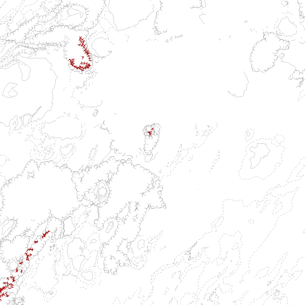
Þekja [layer] j100v_vesturgosbelti_gigar_1utg_li: Gígar á Vesturgosbelti, línulag. [Craters of the Western Volcanic Zone, line data.] Gögn sem sýna gígaröð og útlínur. Gerður er greinarmunur á gossprungum, Holósen útlínur gíga (yngri og eldri en 7000 ára) og gígar frá Kvarter (kuldaskeið/hlýskeiðs). [Data detailing crater rows and outlines. This includes distinctions between eruptive fissure rows, Holocene crater outlines (younger and older than 7000 years), and quarternary (glacial/interglacial) craters.]
-
Þekja [layer] j100v_vesturgosbelti_gigar_1utg_p: Gervigígar, punktalag. [Rootless cones, point data.]
-
Þekja [layer] j100v_vesturgosbelti_jardgrunnur_1utg_li: Jarðgrunnsgögn af Vesturgosbelti Íslands, línulag. [Surface deposits of the Western Volcanic Zone of Iceland, line data.] Kortlagðar eru setmyndanir á yfirborði, s.s. jökulgarðar og jökulset. Nýr kóði fyrir fitjueigindina 'Jarðmyndun og landmótun lausra jarðefna' (jardmLandmJardefna): jm08 = ummerki jökuljaðars. [Mapped surface deposits of moraines and glacial sediments. New code for feature attribute 'Jarðmyndun og landmótun lausra jarðefna' (jardmLandmJardefna): jm08 = traces of ice margin.]
-
Þekja [layer] j100v_vesturgosbelti_lindir_1utg_p: Lindir og hverir á Vesturgosbelti Íslands. [Springs and hotsprings of the Western Volcanic Zone of Iceland.] Gögnin sýna laug, hver, lindir, gufu- og leirhver. Gögn eru ekki flokkuð eftir ÍST120:2012 staðlinum. Hér er flokkun eða lýsing nýrra fitjueiginda: 'tegUppsprettuISOR': 2: 10–25°C (Laug) 3: 25–50°C (Laug) 4: 50–75°C (Laug) 5: 75–98°C (Laug) 6: 98–100°C (Hver) 20: Hrúður 30: Leir- og gufuhverir 7212: Lindir 10–100 l/s 7213: Lindir >100 l/s 7214: Lindasvæði 100–1000 l/s 7215: Lindasvæði >1000 l/s 'tegUppsprettuNI': 1: Lindir 4: Laug (10–98°C) 5: Hver (98–100°C) 6: Leir- og gufuhver 'vatnshiti': Hitastig vatnsins við lindina, mælieining: °C. 'gerdiISOR': Grágrýtislind/Grágrýtislindir: Lind/lindir í hrauni eldra en síðasta jökulskeið, Hraunalind/Hraunalindir: Lind/lindir í nútímahrauni, Móbergslind/Móbergslindir: Lind/lindir í móbergi, Sprungulind: Lind í sprungu. [This data includes cold, warm and hot springs, steam and mud springs. The data does not follow the ÍST120:2012 data standard. Explanation and classification of the new feature attributes: 'tegUppsprettuISOR': 2: 10–25°C (Warm spring) 3: 25–50°C (Warm spring) 4: 50–75°C (Warm spring) 5: 75–98°C (Warm spring) 6: 98–100°C (Boiling spring) 20: Hot spring deposits 30: Mud and steam spring 7212: Cold spring 10–100 l/s 7213: Cold spring >100 l/s 7214: Cold spring area 100–1000 l/s 7215: Cold spring area >1000 l/s 'tegUppsprettuNI': 1: Cold spring 4: Warm spring (10–98°C) 5: Boiling spring (98–100°C) 6: Mud and steam spring 'vatnshiti': Temperature of the spring in °C. 'gerdiISOR': Grágrýtislind/Grágrýtislindir: Spring(s) in 'grey basalt' lavas older than the last glacial, Hraunalind/Hraunalindir: Spring(s) in postglacial lavas, Móbergslind/Móbergslindir: Spring(s) in hyaloclastite tuff, Sprungulind: Spring in tectonic fissure.]
-
Þekja [layer] j100v_vesturgosbelti_jardgrunnur_1utg_fl: Jarðgrunnsgögn af Vesturgosbelti Íslands. [Surface deposits of the Western Volcanic Zone of Iceland.] Laus setlög, svo sem jökulgarðar og árset. [Unconsolidated sediments including glacial morianes and river sediments.]
-
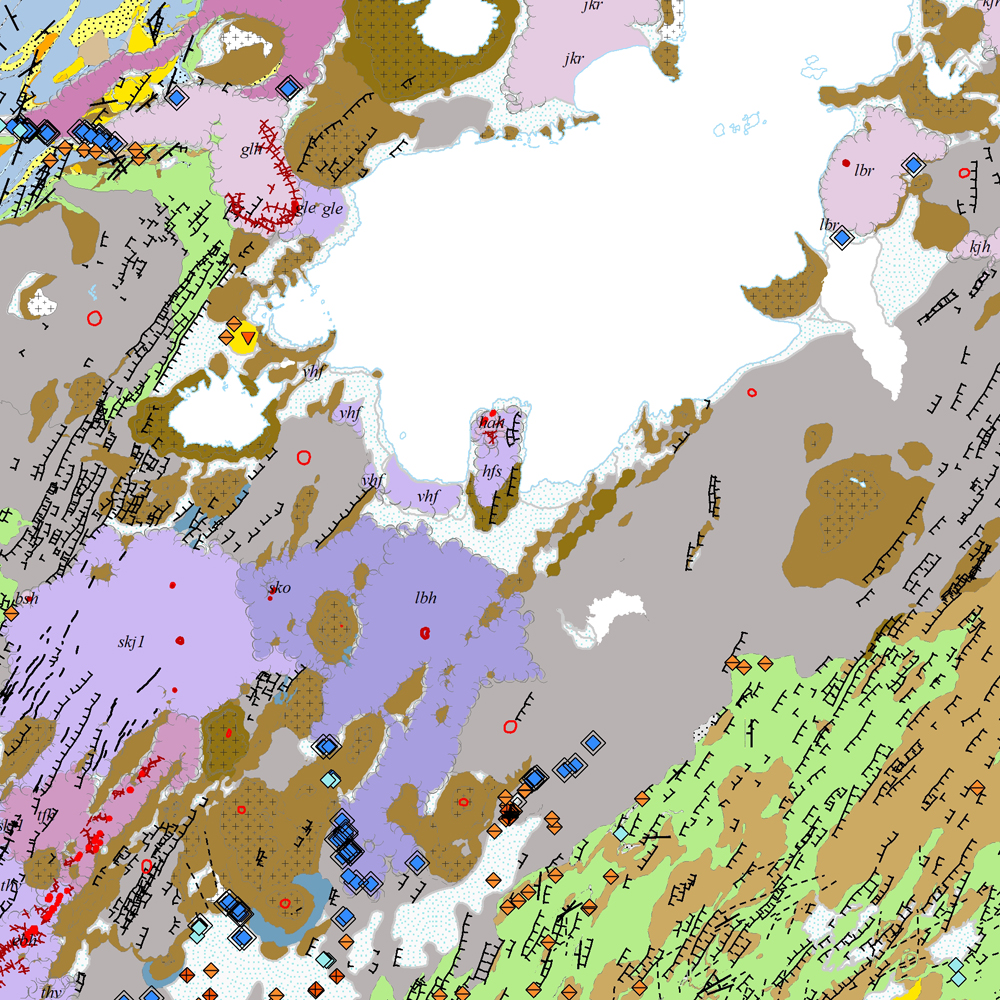
Gagnasafn [GDB] NI_J100v_Vesturgosbelt_1.utg: Jarðfræðikort af Vesturgosbelti Íslands í mælikvarði 1:100.00, 1. útg. [Geological map of the Western Volcanic Zone of Iceland in the scale of 1:100.000, 1st ed.] Kortið sýnir jarðlög, gíga, höggun, strik og halla, framhlaup og niðurföll, steingervinga, jökulrákir, jökulgarða, jökulkembur, malarása og fornar strandlínur stöðuvatna. Jarðlög eru flokkuð eftir aldri, gerð og samsetningu. Kortið var unnin í samstarfi Náttúrufræðistofnunar Íslands og Íslensku Orkurannsoknastofa. Tilvísun: Birgir V. Óskarsson, Ögmundur Erlendsson, Robert A. Askew, Árni Hjartarson, Magnús Á. Sigurgeirsson, Skafti Brynjólfsson og Sveinn Jakobsson 2022. Jarðfræðikort af Vesturgosbelti. 1.100.000. 1. útg. Garðabær: Náttúrufræðistofnun Íslands, Íslenskar Orkurannsóknir og Umhverfis- og Auðlindaráðuneytið. [The map displays bedrock geology, volcanic craters, tectonics, strike and dips, landslides and collapse pits, fossils, glacial striations, glacial moraines, flutes, eskers and ancient lake strandlines. Bedrock is classified by age, type, and composition. The map was completed in a collaborative project between the Icelandic Institute of Natural History and the Icelandic Geosurvey. Bibliographic reference: Birgir V. Óskarsson, Ögmundur Erlendsson, Robert A. Askew, Árni Hjartarson, Magnús Á. Sigurgeirsson, Skafti Brynjólfsson og Sveinn Jakobsson 2022. Geological map of the Western Volcanic Zone, Iceland. 1:100.000. 1st edition. Garðabær: Icelandic Institute of Natural History, Iceland GeoSurvey and Ministry for the Environment and Natural Resources.]
-
Þekja [layer] j100v_vesturgosbelti_hoggun_1utg_li: Höggun á Vesturgosbelti Íslands, línulag. [Tectonic of the Western Volcanic Zone Icelands, line features.] Gögn sýna sprungur, misgengi, gjár, mislægi og brotalínur, kortlagt í mkv. 1:100.000. [Tectonic line features such as faults, fractures, fissures, unconformity, and fracture lines mapped at 1:100,000 scale.]