 Lýsigagnagátt
Evrópuverkefni
Type of resources
Available actions
Topics
INSPIRE themes
Keywords
Contact for the resource
Provided by
Years
Formats
Representation types
Update frequencies
status
Scale
-
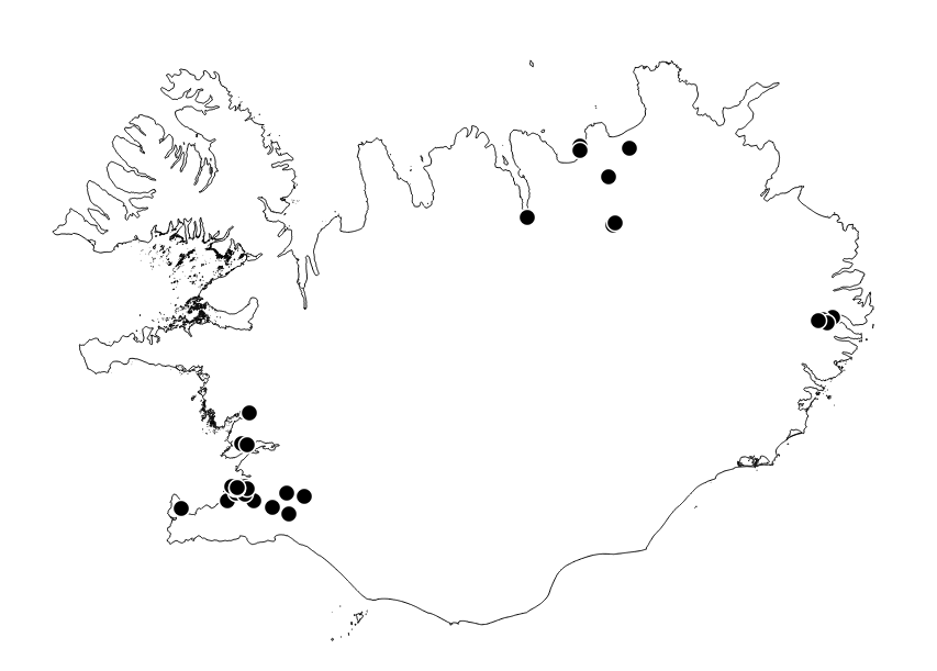
Staðsetningar loftmælistöðva á Íslandi. Umhverfisstofnun skilar árlega loftgæðaskýrslum til Evrópsku umhverfisstofnunarinnar (EEA) og uppfylla þau gögn INSPIRE-tilskipanir varðandi flokkun stöðva. Rekstraraðilar geta breytt gögnum stöðva.
-

Land Cover (LC) is one of 12 themes in the European Location Project (ELF). The purpose of ELF is to create harmonised cross-border, cross-theme, and cross-resolution pan-European reference data from national contributions. The goal is to provide INSPIRE-compliant data for Europe. A description of ELF (European Location Project) is here: http://www.elfproject.eu/content/overview. Encoding: INSPIRE version 4
-

The Corine Land Cover datasets CLC2000, CLC2006and CLC change 2000-2006 are produced within the frame of the GMES land monitoringproject.Corine Land Cover (CLC) provides consistent information on land cover and land cover changes across Europe. This inventory was initiated in 1985 (reference year 1990) and established a time series of land cover information with updates in 2000 and 2006.CLC products are based on photointerpretation of satellite images by national teams of participating countries - the EEA member and cooperating countries – following a standard methodology and nomenclature with the following base parameters: 44 classes in the hierarchical three level Corine nomenclature; minimum mapping unit (MMU) for status layers is 25 hectares; minimum width of linear elements is 100 metres; minimum mapping unit (MMU) for Land Cover Changes (LCC) for the change layers is 5 hectares. The resulting national land cover inventories are further integrated into a seamless land cover map of Europe.Land cover and land use (LCLU) information is important not only for land change research, but also more broadly for the monitoring of environmental change, policy support, the creation of environmental indicators and reporting. CLC datasets provide important datasets supporting the implementation of key priority areas of the Environment Action Programmes of the European Union as protecting ecosystems, halting the loss of biological diversity, tracking the impacts of climate change, assessing developments in agriculture and implementing the EU Water Framework Directive, among others.More about the Corine Land Cover (CLC) and Copernicus land monitoring data in general can be found at http://land.copernicus.eu/.
-

Corine Land Cover (CLC) 2018 and CLC change 2012-2018 are two of the datasets produced within the frame of the Initial Operations of the Copernicus programme (the European Earth monitoring programme previously known as GMES) on land monitoring.Corine Land Cover (CLC) provides consistent information on land cover and land cover changes across Europe. This inventory was initiated in 1985 (reference year 1990) and established a time series of land cover information with updates in 2000, 2006. 2012 and now 2018. CLC products are based on photointerpretation of satellite images by national teams of participating countries - the EEA member and cooperating countries – following a standard methodology and nomenclature with the following base parameters: 44 classes in the hierarchical three level Corine nomenclature; minimum mapping unit (MMU) for status layers is 25 hectares; minimum width of linear elements is 100 metres; minimum mapping unit (MMU) for Land Cover Changes (LCC) for the change layers is 5 hectares. The resulting national land cover inventories are further integrated into a seamless land cover map of Europe. Land cover and land use (LCLU) information is important not only for land change research, but also more broadly for the monitoring of environmental change, policy support, the creation of environmental indicators and reporting. CLC datasets provide important datasets supporting the implementation of key priority areas of the Environment Action Programmes of the European Union as protecting ecosystems, halting the loss of biological diversity, tracking the impacts of climate change, assessing development in agriculture and implementing the EU Water Framework Directive, among others. More about the Corine Land Cover (CLC) and Copernicus land monitoring data in general can be found at http://land.copernicus.eu/
-
Corine Land Cover (CLC) 2012 and CLC change 2006-2012 are two of the datasets produced within the frame of the Initial Operations of the Copernicus programme (the European Earth monitoring programme previously known as GMES) on land monitoring.Corine Land Cover (CLC) provides consistent information on land cover and land cover changes across Europe. This inventory was initiated in 1985 (reference year 1990) and established a time series of land cover information with updates in 2000, 2006 and 2012 being the last one. CLC products are based on photointerpretation of satellite images by national teams of participating countries - the EEA member and cooperating countries – following a standard methodology and nomenclature with the following base parameters: 44 classes in the hierarchical three level Corine nomenclature; minimum mapping unit (MMU) for status layers is 25 hectares; minimum width of linear elements is 100 metres; minimum mapping unit (MMU) for Land Cover Changes (LCC) for the change layers is 5 hectares. The resulting national land cover inventories are further integrated into a seamless land cover map of Europe. Land cover and land use (LCLU) information is important not only for land change research, but also more broadly for the monitoring of environmental change, policy support, the creation of environmental indicators and reporting. CLC datasets provide important datasets supporting the implementation of key priority areas of the Environment Action Programmes of the European Union as protecting ecosystems, halting the loss of biological diversity, tracking the impacts of climate change, assessing developments in agriculture and implementing the EU Water Framework Directive, among others.More about the Corine Land Cover (CLC) and Copernicus land monitoring data in general can be found at http://land.copernicus.eu/.
-

HRL, 6 háupplausnargagnalög: yfirborðsgegndræpi, skógar (trjákrónuþéttleiki), skógar (barrtré/lauftré), graslendi, votlendi, vötn. Rastagögn, 20 m myndpunktsstærð, upprunaleg og endurbætt gagnalög og skýrslur, ISN2004. Hægt er að sækja gögnin á niðurhalssíðu Landmælinga Íslands. Nánari upplýsingar um hvert lag fylgja gögnunum. HRL, 6 High Resolution Layers: imperviousness, tree cover density, forest type, grasslands, wetlands, permanent water bodies. Raster data, 20 m pixel size, intermediate and enhanced results, data and verification/enhancement reports, ISN2004. The datasets can be downloaded from the National Land Survey of Iceland Download Site where more details information about each layer are included.
-

The Corine Land Cover datasets CLC2000, CLC2006 and CLC change 2000-2006 areproduced within the frame of the GMES land monitoring project. Corine Land Cover (CLC) provides consistent information on land cover and land cover changes across Europe. This inventory was initiated in 1985 (reference year 1990) and established a time series of land cover information with updates in 2000 and 2006.CLC products are based on photointerpretation of satellite images by national teams of participating countries - the EEA member and cooperating countries – following a standard methodology and nomenclature with the following base parameters: 44 classes in the hierarchical three level Corine nomenclature; minimum mapping unit (MMU) for status layers is 25 hectares; minimum width of linear elements is 100 metres; minimum mapping unit (MMU) for Land Cover Changes (LCC) for the change layers is 5 hectares. The resulting national land cover inventories are further integrated into a seamless land cover map of Europe.Land cover and land use (LCLU) information is important not only for land change research, but also more broadly for the monitoring of environmental change, policy support, the creation of environmental indicators and reporting. CLC datasets provide important datasets supporting the implementation of key priority areas of the Environment Action Programmes of the European Union as protecting ecosystems, halting the loss of biological diversity, tracking the impacts of climate change, assessing developments in agriculture and implementing the EU Water Framework Directive, among others.More about the Corine Land Cover (CLC) and Copernicus land monitoring data in general can be found at http://land.copernicus.eu/.
-

ELF Geographical Names (GN) Iceland is one of 12 themes in the European Location Project (ELF). The purpose of ELF is to create harmonised cross-border, cross-theme and cross-resolution pan-European reference data from national contributions. The goal is to provide INSPIRE-compliant data for Europe. A description of the ELF (European Location Project) is here: http://www.elfproject.eu/content/overview Encoding: INSPIRE version 4
-

EuroBoundaryMap is a seamless geo-database at the scale 1:100 000 covering 55 countries. It contains geometry, names and codes of administrative and statistical units continuously updated by the members of EuroGeographics, the national mapping and cadastral authorities (NMCAs) of Europe. Updated annually. Datasets in EBM: The EBM dataset was derived from the Icelandic National Database IS 50V, which is at the scale 1:50.000. The generalization has been applied in form of smooth polygon and simplify polygon that ensured the required resolution of the data for the EBM 1: 100 000 scale. The topological relations of the line and area features were ensured. Administrative Units includes: AdministrativeBoundary a line layer containing the demarcations outlining administrative units. AdministrativeUnit_1 a polygon layer containing the national administrative hierarchy, Level 1 (republic). AdministrativeUnit_2 a polygon layer containing the national administrative hierarchy, Level 2 (municipalities). Residence of Authority a point layer containing the administrative centres of all administrative levels. BasicGeometry includes: EBM_A a polygon layer containing administrative areas. Here are the basic components on which administrative units of all hierarchical levels, as well as all statistical layers, are composed. EBM_P a point layer meant for labelling purposes. Label points are located within the main area of the administrative units on lowest level. StatisticalUnits includes: LAU a polygon layer = Local Administrative Unit. NUTS_1 a polygon layer = Nomenclature of Territorial Units for Statistics (whole country) NUTS_2 a polygon layer NUTS_3 a polygon layer = Nomenclature of Territorial Units for Statistics (capital area, rural areas) Tables in EBM: CountryCodes = all countries have unique country codes (icc). EBM_CHR = country codes of those countries where the language is used in alphabetical order delimited by #. EBM_coAdministered = Relationship between administrative unit and its co-administering administrative units on the same hierarchical level. A few countries have special areas with shared administrative units. EBM_ISN = designations of administrative hierarchical levels EBM_NAM = names of administrative units EBM_NUTS = Relationship between the SHN codes of administrative units on lowest national administrative level and corresponding statistical codes.
-

Administrative Units (AU) is one of 12 themes in the European Location Project (ELF). The purpose of ELF is to create harmonised cross-border, cross-theme and cross-resolution pan-European reference data from national contributions. The goal is to provide INSPIRE compliant data for Europe. A description of the ELF (European Location Project) is here: http://www.elfproject.eu/content/overview Encoding: INSPIRE version 4