 Lýsigagnagátt
2009
Type of resources
Available actions
Topics
INSPIRE themes
Keywords
Contact for the resource
Provided by
Years
Formats
Representation types
Update frequencies
status
Scale
-

The Corine Land Cover datasets CLC2000, CLC2006 and CLC change 2000-2006 areproduced within the frame of the GMES land monitoring project. Corine Land Cover (CLC) provides consistent information on land cover and land cover changes across Europe. This inventory was initiated in 1985 (reference year 1990) and established a time series of land cover information with updates in 2000 and 2006.CLC products are based on photointerpretation of satellite images by national teams of participating countries - the EEA member and cooperating countries – following a standard methodology and nomenclature with the following base parameters: 44 classes in the hierarchical three level Corine nomenclature; minimum mapping unit (MMU) for status layers is 25 hectares; minimum width of linear elements is 100 metres; minimum mapping unit (MMU) for Land Cover Changes (LCC) for the change layers is 5 hectares. The resulting national land cover inventories are further integrated into a seamless land cover map of Europe.Land cover and land use (LCLU) information is important not only for land change research, but also more broadly for the monitoring of environmental change, policy support, the creation of environmental indicators and reporting. CLC datasets provide important datasets supporting the implementation of key priority areas of the Environment Action Programmes of the European Union as protecting ecosystems, halting the loss of biological diversity, tracking the impacts of climate change, assessing developments in agriculture and implementing the EU Water Framework Directive, among others.More about the Corine Land Cover (CLC) and Copernicus land monitoring data in general can be found at http://land.copernicus.eu/.
-

The Corine Land Cover datasets CLC2000, CLC2006and CLC change 2000-2006areproduced within the frame of the GMES land monitoringproject.Corine Land Cover (CLC) provides consistent information on land cover and land cover changes across Europe. This inventory was initiated in 1985 (reference year 1990) and established a time series of land cover information with updates in 2000 and 2006.CLC products are based on photointerpretation of satellite images by national teams of participating countries - the EEA member and cooperating countries – following a standard methodology and nomenclature with the following base parameters: 44 classes in the hierarchical three level Corine nomenclature; minimum mapping unit (MMU) for status layers is 25 hectares; minimum width of linear elements is 100 metres; minimum mapping unit (MMU) for Land Cover Changes (LCC) for the change layers is 5 hectares. The resulting national land cover inventories are further integrated into a seamless land cover map of Europe.Land cover and land use (LCLU) information is important not only for land change research, but also more broadly for the monitoring of environmental change, policy support, the creation of environmental indicators and reporting. CLC datasets provide important datasets supporting the implementation of key priority areas of the Environment Action Programmes of the European Union as protecting ecosystems, halting the loss of biological diversity, tracking the impacts of climate change, assessing developments in agriculture and implementing the EU Water Framework Directive, among others.More about the Corine Land Cover (CLC) and Copernicus land monitoring data in general can be found at http://land.copernicus.eu/.
-

Gagnasafn (GDB) NI_J600v_hoggun: Jarðfræðikorti af Íslandi – Höggun – 1:600.000 [Geological Map of Iceland – Tectonics – 1:600.000]. Höggunarkort af Íslandi sýnir jarðfræði landsins á nýstárlegan hátt. Jarðlög eru flokkuð eftir aldri en ekki eftir gerð og samsetningu. Sýnd eru eldstöðvakerfi, þ.e. megineldstöðvar, sprungu- og gangareinar, bæði virkar og útkulnaðar. Einnig eru sýnd helstu brotakerfi landsins og halli jarðlaga. Kortið gefur innsýn í jarðfræðilega byggingu landsins. [The Tectonic Map of Iceland gives a new view of the country's geology. The rocks are classified by age, but not by type or composition. Volcanic systems including central volcanoes, fissures and dyke swarms, both active and extinct, are shown, as are the island's principal fracture zones and the dip of rock layers. The map thus gives a useful insight into the geological structure of the country.]
-
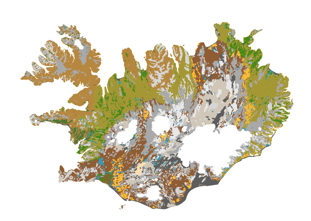
Íslenskur jarðvegur telst til eldfjallajarðar (Andosol) að langmestum hluta, en eldfjallajörð er jarðvegur sem myndast á eldvirkum svæðum heimsins. Eldfjallajörð hefur afar sérstæða eiginleika sem greina hana frá öðrum jarðvegsgerðum. Útbúin var einföld flokkun fyrir íslenskan jarðveg, sem m.a. byggist á alþjóðlegum flokkunarkerfum en einnig á vinnu Björns Jóhannessonar og Þorsteins Guðmundssonar. Flokkunin gerir greinarmun á i) jarðvegi auðna (glerjörð sem skiptist í melajörð, malarjörð, sandjörð og vikurjörð; ii) jarðvegi gróins lands með sortueiginleika (sortujörð, sem skiptist í brúnjörð, votjörð og svartjörð), iii) lífrænni mójörð og að síðustu iv) öðrum jarðvegi sem er margvíslegur að gerð. Í síðasta flokknum er bergjörð útbreiddust, en auk þess má nefna frerajörð sífrerasvæða og kalkjörð. Jarðvegskortið var unnið á grundvelli sniða og jarðvegssýna sem safnað hefur verið víða um landið. Kortið er á vektora formi og í mælikvarða 1:500 000. Það er m.a. hluti evrópska jarðvegskortsins. A soil map of Iceland: The Soil map classification separates between; 1) andic soils, which are Brown Andosols, Gleyic Andosols and Histic Andosols; 2) Vitrisols, soils of deserts, which are divided into Cambic Vitrisols, Gravelly Vitrisols, Arenic Vitrisols and Pumice Vitrisols iii) Histosols, and iv) other soil types such as Cryosols and Leptosols. The classification system is in part based on WRB system and Soil Taxonomy and earlier work by Björn Jóhannesson and Þorsteinn Guðmundsson (see English Summary and 1. table in http://www.moldin.net/uploads/3/9/3/3/39332633/jardvegskort_2.pdf). The map is in a coarse scale (1:500 000) and is not intended to use for particular points on the landscape. It is rather an overview. It has been incorporated into the EU soil database and the Circumpolar soil map.
-

The Corine Land Cover datasets CLC2000, CLC2006and CLC change 2000-2006 are produced within the frame of the GMES land monitoringproject.Corine Land Cover (CLC) provides consistent information on land cover and land cover changes across Europe. This inventory was initiated in 1985 (reference year 1990) and established a time series of land cover information with updates in 2000 and 2006.CLC products are based on photointerpretation of satellite images by national teams of participating countries - the EEA member and cooperating countries – following a standard methodology and nomenclature with the following base parameters: 44 classes in the hierarchical three level Corine nomenclature; minimum mapping unit (MMU) for status layers is 25 hectares; minimum width of linear elements is 100 metres; minimum mapping unit (MMU) for Land Cover Changes (LCC) for the change layers is 5 hectares. The resulting national land cover inventories are further integrated into a seamless land cover map of Europe.Land cover and land use (LCLU) information is important not only for land change research, but also more broadly for the monitoring of environmental change, policy support, the creation of environmental indicators and reporting. CLC datasets provide important datasets supporting the implementation of key priority areas of the Environment Action Programmes of the European Union as protecting ecosystems, halting the loss of biological diversity, tracking the impacts of climate change, assessing developments in agriculture and implementing the EU Water Framework Directive, among others.More about the Corine Land Cover (CLC) and Copernicus land monitoring data in general can be found at http://land.copernicus.eu/.
-
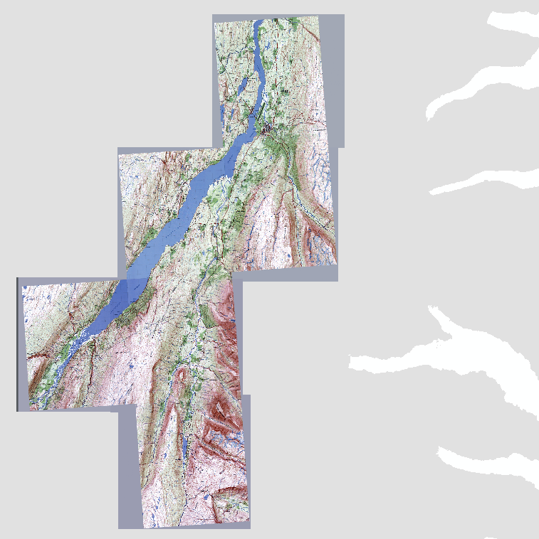
Safn skannaðra Íslandskorta í kvarðanum 1:25.000, svokölluð staðfræðikort gerð hjá Landmælingum Íslands á níunda áratug síðustu aldar. Uppréttar GeoTIFF myndir sem varpað var úr VisIT hugbúnaðinum þegar kortin voru gefin út á diskum. Hægt er að sækja kortin á niðurhalssíðu Náttúrufræðistofnunar í tveimur pökkum. Annars vegar er um að ræða kortablöð fyrir Egilsstaði, Hallormsstaði, Lagarfljót, Sauðahlíðarfjall, Skriðudal og Suðurdal. Hins vegar eru kortablöð fyrir Heiðmörk, Keflavík og Krísuvík.
-

Skannað Íslandskort í kvarðanum 1:750.000, svokallað ferðakort. Upprétt GeoTIFF mynd sem varpað var úr VisIT hugbúnaðinum þegar kortið voru gefið út á diskum.
-

Heildarsafn skannaðra Íslandskorta í kvarðanum 1:250.000, svokölluð Aðalkort. Uppréttar GeoTIFF myndir sem varpað var úr VisIT hugbúnaðinum þegar kortin voru gefin út á diskum.
-

Þetta lag sýnir gömlu sýslurnar og er unnið úr IS 50V gögnum. Er byggt á korti frá LMÍ sem kom út árið 1990 (heitir: Hreppa- og sýsluskipting).