 Lýsigagnagátt
asNeeded
Type of resources
Available actions
Topics
INSPIRE themes
Keywords
Contact for the resource
Provided by
Years
Formats
Representation types
Update frequencies
status
Scale
-
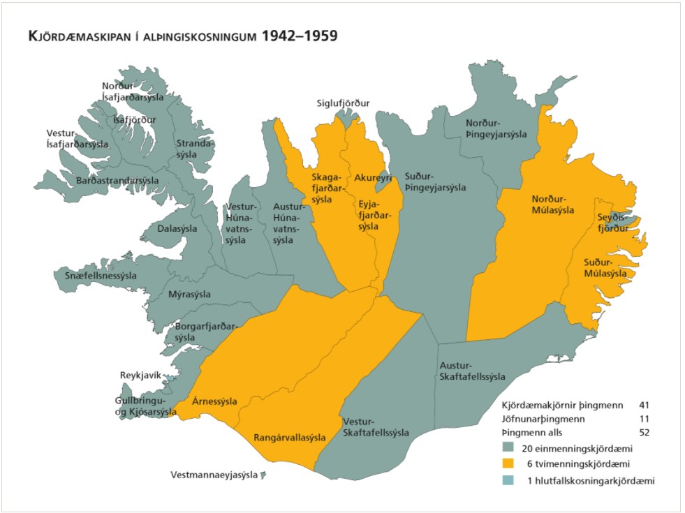
Kjördæmi eru afmörkuð landsvæði sem mynda einn af grunnþáttum kosningakerfisins. Framboðslistar eru lagðir fram fyrir hvert og eitt kjördæmi þannig að kjósendur í sama kjördæminu geta valið á milli sömu framboðslistanna og kjörnir fulltrúar hljóta þar umboð sitt til þingsetu. Kjördæmaskipulagið og fjöldi kjósenda í hverju þeirra liggur til grundvallar þegar þingsætum er úthlutað eftir þingkosningar. Þar sem kjördæmaskipulagið er ráðandi fyrir vægi atkvæða kjósenda hefur það mikil áhrif á það hvaða frambjóðendur fá sæti á þingi að loknum kosningum. Kjördæmaskipulagið er því meðal þess sem oft hefur orðið að deiluefni. Þegar gerðar voru á því verulegar breytingar kostuðu þær jafnan pólitísk átök og allar hafa þær þýtt málamiðlanir milli ólíkra sjónarmiða. Tekið af vef Alþingis: https://www.althingi.is/thingmenn/althingiskosningar/kosningar-og-kosningaurslit/kjordaemaskipulagid/
-

Línurnar sýna friðunarsvæði, þar sem eldi laxfiska (fam. salmonidae) í sjókvíum er óheimilt skv. auglýsingu nr. 460/2004.
-
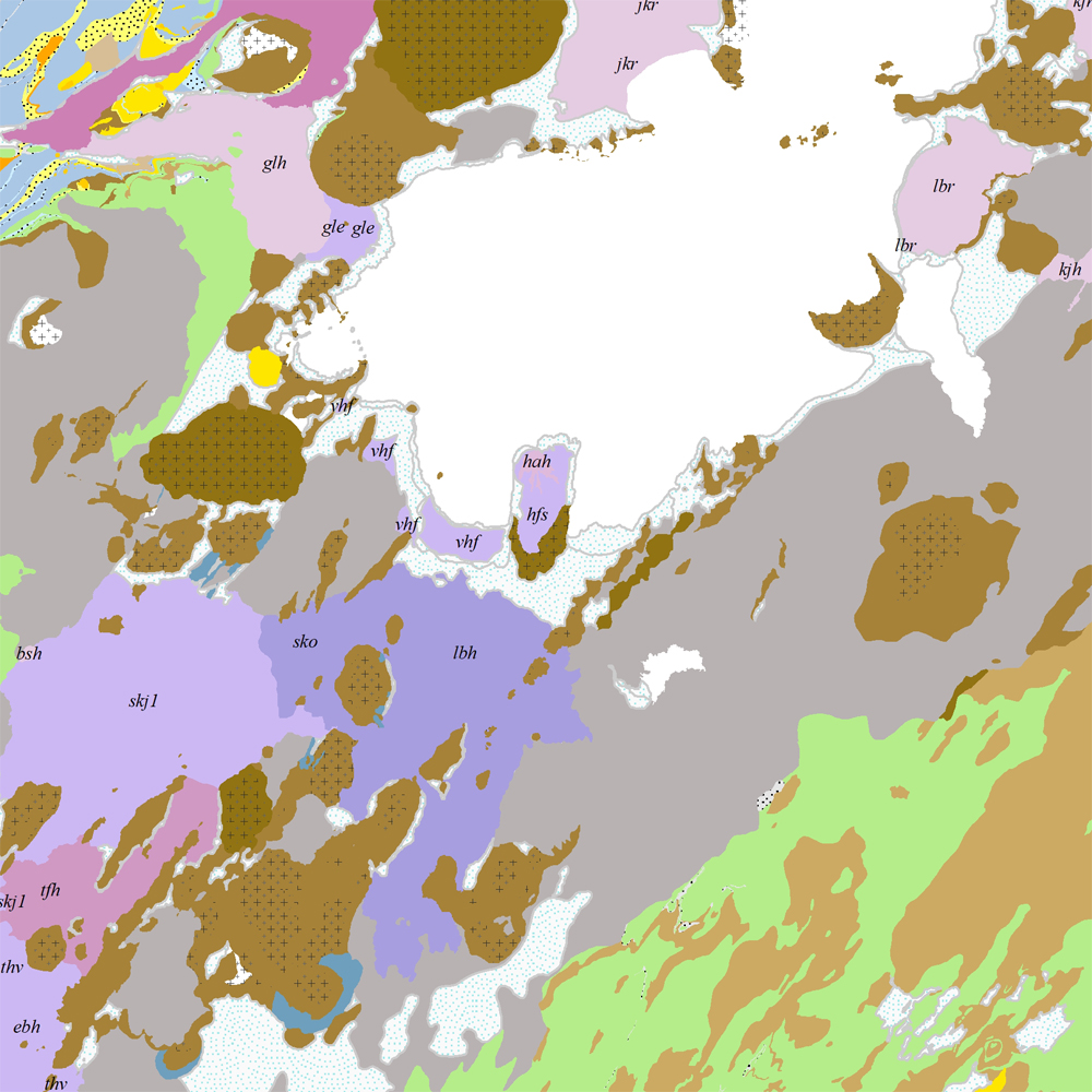
Þekja [layer] j100v_vesturgosbelti_berggrunnur_1utg_fl: Gögn fyrir berggrunn ásamt nútímahraunum. [Data showing the bedrock geology, including Holocene lavas.] Berggrunnur er flokkaður eftir aldri, gerð og samsetningu. Gögn eru flokkuð eftir ÍST120:2012 staðlinum, nema fitjueigindir: myndunKodi = stuttur kóði sem táknar gerð bergmyndunar, myndunIS = stutt íslenskt heiti fyrir bergmyndun, myndunEN = stutt enskt nafn á bergmyndun, eldstodNafn = nafn eldstöðvakerfis, kenni = stuttur kóði fyrir hlýskeiðishraun og nútímahraun, aldur = aldursbil, Nýr kóði fyrir fitjueigindina 'Tegund storkubergs' (tegStorkubergs): dbas = dílabasalt. [Bedrock is classified by age, type, and composition. The data follows the ÍST120:2012 data standard with these additional feature attributes: myndunKodi = short code denoting the rock formation type, myndunIS = short Icelandic name for rock formation, myndunEN = short English name for rock formation, eldstodNafn = name of the volcanic system, kenni = short codename for interglacial and postglacial lavas, aldur = age range. New code for feature attribute 'Tegund storkubergs' (tegStorkubergs): dbas = porphyrytic basalt.]
-
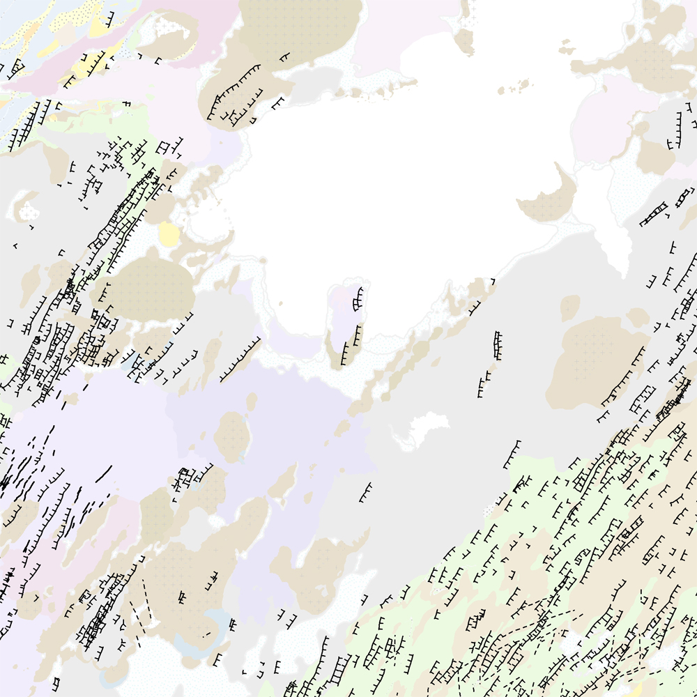
Þekja [layer] j100v_vesturgosbelti_hoggun_1utg_li: Höggun á Vesturgosbelti Íslands, línulag. [Tectonic of the Western Volcanic Zone Icelands, line features.] Gögn sýna sprungur, misgengi, gjár, mislægi og brotalínur, kortlagt í mkv. 1:100.000. [Tectonic line features such as faults, fractures, fissures, unconformity, and fracture lines mapped at 1:100,000 scale.]
-

Upplýsingar um eldissvæði í sjókvíaeldi sem eru í umsóknarferli hjá Matvælastofnun.
-

Gögnin voru tekin saman í byrjun árs 2015. Þau eru sett saman úr dýptarlínum úr sjókortum í tveimur mælikvörðum. Annars vegar í 1:100.000 og hins vegar í 1:300.000. Dýptarlínur í sjókortum eru ekki með jöfnu bili. Dýptarlínurnar eru þessar: 10 m, 20 m, 50 m, 75 m, 100 m, 150 m, 200 m, 300 m, 400 m, 500 m, 1000 m, 1500 m og 2000 m. Landhelgisgæsla Íslands safnaði gögnunum og annast um drefingu. Gögnin ná ekki til alls landsins. Helstu eigindi eru jafndýpislínur með dýpisgildi. Um er að ræða stök kort eða samsett í stærri heild á shape formi.
-

Umsóknin um Þingvelli á heimsminjaskrá var lögð fram í febrúar 2003 og var hún samþykkt á fundi heimsminjanefndar UNESCO í júlí 2004. Þingvellir eru þjóðgarður sem var með lögum stofnaður árið 1930.
-
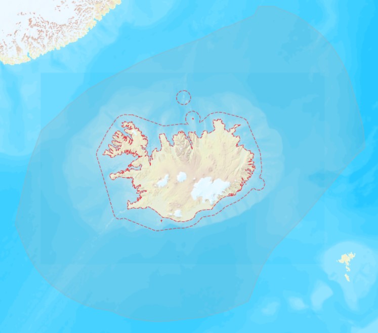
Landhelgi Íslands er skilgreind í lögum nr. 41/1979 með síðari breytingum frá 15. október 2021. Heiti laganna er Lög um landhelgi, aðlægt belti, efnahagslögsögu og landgrunn. Í lögunum eru skilgreiningar og útskýringar á aðlægu belti, efnahagslögsögu og landgrunni Íslands: https://www.althingi.is/lagas/nuna/1979041.html Landhelgi Íslands skal afmörkuð af línu sem alls staðar er 12 sjómílur frá grunnlínu. Grunnlína er sett fram sem lína en einnig punktar. Línan er dregin milli punktanna. Aðlægt belti er svæði utan landhelgi (línur). Efnahagslögsaga Íslands er svæði utan landhelgi (línur). Vinsamlega hafið samband við Landhelgisgæslu Íslands vegna nánari upplýsinga.
-

Akkeri og baujur og áætlaðar staðsetningar fyrir búnað í sjókvíaeldi.
-
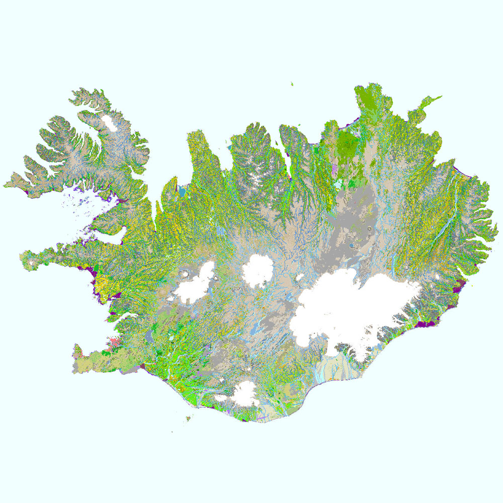
Gagnaset (data set) ni_vg25v_1.1utg: Vistgerðir á Íslandi: ferskvatn og fjörur (Habitat types of Iceland: freshwater and littoral shores). Vistgerðakortið sýnir útbreiðslu ferskvatns- og fjöruvistgerða á Íslandi. Alls hafa verið ákvarðaðar 17 vistgerðir fyrir ferskvatn og 24 vistgerðir fyrir fjörur. Ferskvatnsvistgerðir skiptast í tvö þrep, en fjöruvistgerðir í fimm þrep. Við skilgreiningu og flokkun vistgerða á Íslandi var tekið mið af EUNIS-flokkunarkerfinu (European Environment Agency 2012) . Landupplýsingaþekjan fyrir jarðhita, ferskvatns- og fjöruvistgerðir er á vektorformi. Vektorþekjurnar eru flestar flákaþekjur, en fyrir ferskvatn er einnig línu- og punktaþekja. Gögn fyrir stöðuvötn (vg2 = V1) eru fjarlægð tímabundið úr niðurhalsþjónustu vegna ágreinings um grunnkort Loftmynda ehf. en þekjan er sýnileg í kortasjá. Náttúrufræðistofnun Íslands leggur með ritinu Vistgerðir á Íslandi fram tillögur að flokkun vistgerða sem á sér fyrirmynd í samræmdri og viðurkenndri flokkun vistgerða í Evrópu. Flokkunin byggir á rannsóknum víða um land með fyrirvara um að bæta mætti í þá þekkingu. Frekari upplýsingar um flokkun og skilgreiningu vistgerða má sjá í ritinu: Jón Gunnar Ottósson, Anna Sveinsdóttir og María Harðardóttir, ritstj. 2016. Vistgerðir á Íslandi. Fjölrit Náttúrufræðistofnunar nr. 54. 299 s. og á vef Náttúrufræðistofnunar.