Type of resources
Available actions
Topics
INSPIRE themes
Keywords
Contact for the resource
Provided by
Years
Formats
Representation types
Update frequencies
status
Service types
Scale
Resolution
From 1 - 10 / 473
  • Categories  

    Skoðunarþjónustur Fiskistofu
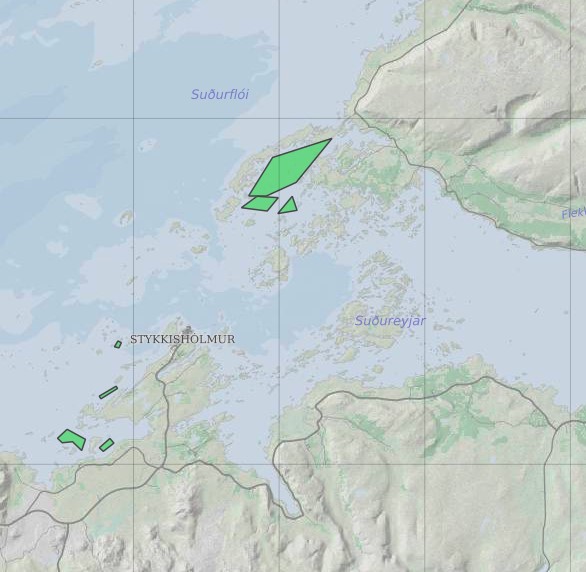
  • The European Organisation for the Exploitation of Meteorological Satellites (EUMETSAT) is an intergovernmental organization founded in 1986, consisting of 30 member states dedicated to the operation of meteorological satellites for monitoring weather, climate, and environmental phenomena. Headquartered in Darmstadt, Germany, EUMETSAT plays a crucial role in providing accurate and timely data and services to meteorological agencies, researchers, and policymakers worldwide. EUMETSAT operates a fleet of geostationary and polar-orbiting satellites equipped with a variety of instruments for observing Earth's atmosphere, oceans, and land surfaces. These satellites capture a wealth of data on weather patterns, atmospheric composition, sea surface temperatures, and other meteorological and environmental parameters. By integrating data from its satellites with ground-based observations and numerical weather prediction models, EUMETSAT produces a wide range of products and services to support weather forecasting, climate monitoring, and environmental analysis. One of EUMETSAT's primary data dissemination channels is its EUMETCast system, a satellite-based data distribution network that delivers real-time and near-real-time satellite data, imagery, and products directly to users' ground receiving stations. Through EUMETCast, meteorological agencies, research institutions, and other users can access a wealth of meteorological and environmental data for use in weather forecasting, climate research, and disaster management applications. In addition to data dissemination, EUMETSAT offers a range of services and products tailored to the needs of its users. These include operational weather forecasting services, such as the Nowcasting SAF (Satellite Application Facility) and the Numerical Weather Prediction SAF, which provide specialized products for short-range weather prediction. EUMETSAT also collaborates with other international organizations, such as the European Centre for Medium-Range Weather Forecasts (ECMWF) and the World Meteorological Organization (WMO), to develop and deliver joint products and services for global weather and climate monitoring. Overall, EUMETSAT plays a critical role in advancing meteorological science and enhancing our understanding of Earth's weather and climate system. By operating state-of-the-art satellite systems and providing comprehensive data and services, EUMETSAT contributes to improved weather forecasting, climate monitoring, and disaster preparedness, ultimately benefiting society and the environment. This page serves as a description of the service and access to their data portal.

  • Categories  

    IS: Í Minjavefsjánni er að finna upplýsingar um menningarminjar á Íslandi. EN: Minjavefsjá - Cultural and Archeological Heritage Map serves as a digital platform for accessing and exploring cultural heritage information and resources related to Iceland's history, archaeology, architecture, art, folklore, and other aspects of cultural heritage. It provides a valuable tool to disseminate information and location of protected archeological sites, preserved historical houses, archeological monuments, location of current archeological research and operations and much more.

  • Categories  

    IS: Í Kortasjá Náttúrufræðistofnunar er meðal annars hægt að velja kort með örnefnum, loftmyndir, atlaskort eða AMS kort. Þá er þar að finna sveitarfélagakort með upplýsingum um stærð sveitarfélaga og íbúarfjölda, þekju með CORINE landflokkun sem sýnir til dæmis mólendi eða mýrlendi og gamlar ljósmyndir danskra landmælingamanna sem og gamlar bæjarteikningar. EN: Kortasjá from Institute of Nature Research is a simple and reactive map where the user can view placenames, protected areas, Corine classification, roads, height points, buildings, boundaries of municipalities, and more.

  • Categories  

    Niðurhalsþjónustur Ferðamálastofu

  • Categories  

    [IS] WMS þjónusta fyrir drónamyndir frá Landmælingum Íslands. [EN] WMS service to serve drone imagery from the national land survey of Iceland.

  • Categories  

    Average near-East crustal velocities between summer 2015 and summer 2018. These velocities indicate velocities in the East direction. However, they could be slightly influence by velocities along the North and Up directions and are therefore called near-East. Near-East velocities were derived by decomposing the line-of-sight velocities of six Sentinel-1 interferometric time-series covering Iceland. These time-series used a single master approach and Sentinel-1 images from the following summers (mid-June to end of September): 2015, 2016, 2017, and 2018. The near-East velocity grid has a 50 m resolution.

  • Categories  

    Þann 16. mars 2011 gáfu Náttúrufræðistofnun út í fyrsta sinn sameiginlegt hæðarkerfi fyrir Ísland. Kerfið er kallað Landshæðarkerfi Íslands og er viðmiðunin ISH2004. Tilkoma sameiginlegs hæðarkerfis markaði stór tímamót í sögu landmælinga á Íslandi. Á sama hátt og viðmiðunin ISN93 skapaði grundvöll fyrir alla til að vinna í sama hnitakerfi mun ISH2004 skapa grundvöll fyrir alla til að vinna í sama hæðarkerfi. Eitt samræmt hæðarkerfi er mikilvægt fyrir ýmsar framkvæmdir s.s. vegagerð og jarðgangnagerð og á ýmsum sviðum umhverfisvöktunar, skipulags og áætlanagerðar. Auk þess munu gögnin nýtast við rannsóknir á jarðskorpuhreyfingum eða breytingum á yfirborði sjávar. Mælingar á Landshæðarkerfinu eru standa ennþá yfir og frá fyrstu útgáfu þess árið 2011 hafa bæst við eftirfarandi línur hallamælilínur. • Flókalundur-Bolungavík • Reykjavík-Keflavík • Endurmæling á Suðurlandi vegna jarðskjálftans 2008 • Hellisheiði • Reykjanesbraut-Grindavík • Þjóðvegur 1-Akranes • Kjölur Niðurstöður nýrra mælinga verður bætt inn í þetta gagnasett um leið og þær liggja fyrir.

  • Categories  

    [IS] Í Rammasjá er hægt að skoða gögn sem tengjast áætlun um vernd og orkunýtingu landsvæða, þ.e.a.s. Rammaáætlun. [EN] The Master Plan for Nature Protection and Energy Utilization Map

  • Categories  

    Lagið sýnir helstu vatnaskil á Reykjanesskaga. Gögn eru frá VÍ og eru uppfærð eftir þörfum.