 Lýsigagnagátt
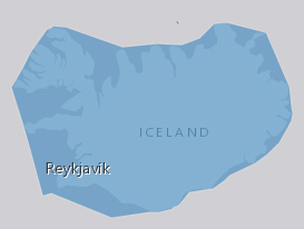
RiverBasinDistrict IS 20181222
EN: Boundary of River Basin District(s) of Iceland as reported to WISE on 22.12.2018."River basin district" means the area of land and sea, made up of one or more neighbouring river basins together with their associated groundwaters and coastal waters, which is identified under Article 3(1) as the main unit for management of river basins.For further description of dataset fields and field values see GML schema here.
http://dd.eionet.europa.eu/schemas/WFD2016/GML_RiverBasinDistrict_2016.xsd
IS: Vatnaumdæmi Íslands miðað við skil inn í WISE upplýsingakerfið þann 22.12.2018. Vatnaumdæmi er stjórnsýslueining sem nær til íslenskra vatnasvæða ásamt árósavatni og strandsjó sem þeim tengjasteins og það er skilgreint í lögum nr. 35/2011 og reglugerð nr.935/2011 um Stjórn vatnamála. Nánari lýsing á eigindum og gildum gagnasettsins má finna í GML skema hér:
http://dd.eionet.europa.eu/schemas/WFD2016/GML_RiverBasinDistrict_2016.xsd
Simple
- Date ( Publication )
- 2018-12-22
- Edition
- 20181222
- Status
- Completed
- Maintenance and update frequency
- As needed
- Keywords
-
- INSPIRE
- River basin district
- water
- Vatnaumdæmi
- Stjórn Vatnamála
- Priority dataset
- GSL
- Legislation Level ( Theme )
- Topic categories in accordance with EN ISO 19115 ( Theme )
-
- Inland Waters
- INSPIRE priority data set ( Theme )
- INSPIRE application schema register ( Theme )
-
- Area Management Restriction and Regulation Zones
- GEMET - INSPIRE themes, version 1.0 ( Theme )
- Use constraints
- Other restrictions
- Other constraints
- This work is licensed under a Creative Commons Attribution 4.0 International License (CC-BY)
- Access constraints
- Other restrictions
- Other constraints
- no limitations to public access
- Spatial representation type
- Vector
- Denominator
- 50000
- Metadata language
- en
- Character set
- UTF8
- Topic category
-
- Inland waters
- Begin date
- 2018-12-22
- End date
- 2022-03-22
))
- Reference system identifier
- http://www.opengis.net/def/crs/EPSG/0/4326
- Distribution format
-
-
GeoTIFF
(
1.0
)
-
KML
(
0
)
-
PNG
(
0
)
-
GML
(
3.2.1
)
-
ZIP
(
0
)
-
GeoTIFF
(
1.0
)
- OnLine resource
-
Eionet
(
WWW:LINK-1.0-http--link
)
Further information of data set fields and field values see GML schema
- OnLine resource
- Icelandic Met Office ( WWW:LINK-1.0-http--link )
- OnLine resource
-
Opin gögn - Stjórn Vatnamála
(
WWW:LINK-1.0-http--link
)
Heimasíða með opinberum upplýsingum um stjórn vatnamála.
- OnLine resource
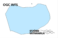
- https://dservices1.arcgis.com/s4ES6RrX27tE99NO/arcgis/services/WFS_RiverBasinDistrict_IS_20181222/WFSServer?service=wfs&request=getcapabilities ( OGC:WFS )
- OnLine resource
- WISE GIS guidance (v6.0.6 2016-04-29) ( WWW:LINK-1.0-http--related )
- OnLine resource
- Stjórn vatnamála ( WWW:LINK-1.0-http--partners )
- Hierarchy level
- Dataset
Conformance result
- Date ( Publication )
- 2010-12-08
- Explanation
- Validation has not been performed.
- Pass
- No
- Statement
- The data has been both topologically and attribute value verified and validated internally and conforms to all WISE GIS guidance requirements on the reporting of spatial data to WISE (v6.0.6).
gmd:MD_Metadata
- File identifier
- e71161a2-d221-4394-82ce-9b48ca3a5acc XML
- Metadata language
- en
- Character set
- UTF8
- Hierarchy level
- Dataset
- Date stamp
- 2021-12-15T19:43:02
- Metadata standard name
- INSPIRE Metadata Implementing Rules
- Metadata standard version
- Technical Guidelines based on EN ISO 19115 and EN ISO 19119 (Version 1.2)
http://www.vedur.is/
Overviews
Spatial extent
Provided by
