 Lýsigagnagátt
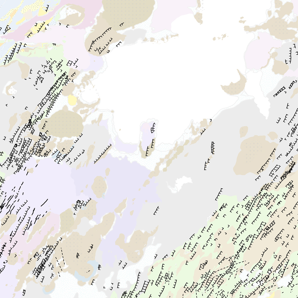
ni_j100v Höggun á Vesturgosbelti – 1:100.000
Þekja [layer] j100v_vesturgosbelti_hoggun_1utg_li:
Höggun á Vesturgosbelti Íslands, línulag. [Tectonic of the Western Volcanic Zone Icelands, line features.]
Gögn sýna sprungur, misgengi, gjár, mislægi og brotalínur, kortlagt í mkv. 1:100.000.
[Tectonic line features such as faults, fractures, fissures, unconformity, and fracture lines mapped at 1:100,000 scale.]
Simple
- Date ( Publication )
- 2021-12-01
- Edition
- 1. útgáfa
- Status
- On going
- Maintenance and update frequency
- As needed
- Keywords ( Theme )
-
- Keywords ( Place )
-
- National
- GEMET - INSPIRE themes, version 1.0 ( Theme )
-
- Geology
- Access constraints
- Copyright
- Use constraints
- Copyright
- Other constraints
-
http://www.ni.is/rannsoknir/landupplysingar/skilmalar
Gögnin eru öllum opin – no limitations on public access.
- Spatial representation type
- Vector
- Denominator
- 100000
- Metadata language
- en
- Character set
- UTF8
- Topic category
-
- Geoscientific information
- Begin date
- 2019-05-01
- End date
- 2019-06-01
))
- Reference system identifier
- EPSG / 3057 / 7.6.1(9.0.0)
- Distribution format
-
-
ESRI ArcGIS File Geodatabase
(
1.010.8.1.14362
)
-
ESRI Shapefile
(
1.010.8.1.14362
)
-
ESRI ArcGIS File Geodatabase
(
1.010.8.1.14362
)
- OnLine resource
- Niðurhalssíða Náttúrufræðistofnunar Íslands ( WWW:LINK-1.0-http--link )
- OnLine resource
- Skilmálar (PDF) – Licence (PDF) ( WWW:LINK-1.0-http--link )
- OnLine resource
- NÍ kortasjá 'Jarðfræði Íslands' ( WWW:LINK-1.0-http--link )
- OnLine resource
- Vefur Náttúrufræðistofnunar ( WWW:LINK-1.0-http--link )
- OnLine resource
- Íslenskt fitjuskrá '600 Jarðmyndun og landmótun' sem tengjast staðlinum ÍST 120 (PDF) ( WWW:LINK-1.0-http--link )
- Hierarchy level
- Feature
- Statement
-
Gögnin eru úr vettvangsvinnu, loftmyndagreining og DEM, og þekjur frá Hjartadóttir et al (2016).
[Compiled from field data, analysis of DEM and aerial imagery and previous work e.g. Hjártadóttir et al (2016).]
Heimildir [Sources]:
- Hjartardóttir, Á.R., Einarsson, P. and Björgvinsdóttir, S.G. 2016. Fissure swarms and fracture systems within the Western Volcanic Zone, Iceland–effects of spreading rates. Journal of Structural Geology, 91, pp.39-53.
- Jóhannesson, H. 2014. Geological map of Iceland, 1:600,000. Icelandic Institute of Natural History.
gmd:MD_Metadata
- File identifier
- e6f4813b-6347-4ca3-a1cd-4a9cd4d28f4b XML
- Metadata language
- en
- Character set
- UTF8
- Parent identifier
- NI_J100v Jarðfræðikort af Vesturgosbelti 1. útgáfa – 1:100.000 eeca904b-c6b9-42b2-827a-184d1b8ff46e
- Date stamp
- 2024-08-19T14:55:53
- Metadata standard name
- ISO 19115:2003/19139
- Metadata standard version
- 1.0
Overviews
Spatial extent
Provided by
