 Lýsigagnagátt
SubUnit IS 20181222
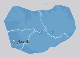
EN: Boundary of Icelandic River Basin Sub unit(s) as reported to WISE on 22.12.2018. A "Sub unit" is a defined area that includes one or more catchments. For international reporting purposes only one Sub unit is used (ID: IS100) which covers the same area as the Icelandic River Basin District. For national management and reporting purposes there are four Sub Units (ID's: IS101, IS102, IS103, IS104). For further description of dataset fields and field values see GML schema here:
http://dd.eionet.europa.eu/schemas/WFD2016/GML_SubUnit_2016.xsd
IS: Afmörkun íslenskra vatnasvæða miðað við skil inn í WISE upplýsingakerfið þann 22.12.2018. "Vatnasvæði" er landsvæði með einu eða fleiri vatnasviðum. Vegna skýrslugjafar til Evrópusambandsins er aðeins eitt vatnasvæði notað (ID:IS100) sem nær yfir sama svæði og Vatnaumdæmi Íslands. Vegna innlendrar stjórnunar og skýrslugjafar eru fjögur vatnasvæði notuð (IDs: IS101, IS102, IS103, IS104). Nánari lýsing á eigindum og gildum gagnasettsins má finna í GML skema hér:
http://dd.eionet.europa.eu/schemas/WFD2016/GML_SubUnit_2016.xsd
Simple
- Date ( Publication )
- 2018-12-22
- Status
- Completed
- Maintenance and update frequency
- As needed
- Keywords
-
- INSPIRE
- River basin district
- water
- Vatnasvæði
- Stjórn Vatnamála
- Priority dataset
- GSL
- Legislation Level ( Theme )
- INSPIRE priority data set ( Theme )
- GEMET - INSPIRE themes, version 1.0 ( Theme )
- Use constraints
- Other restrictions
- Other constraints
- This work is licensed under a Creative Commons Attribution 4.0 International License (CC-BY)
- Access constraints
- Other restrictions
- Other constraints
- no limitations to public access
- Spatial representation type
- Vector
- Denominator
- 50000
- Metadata language
- en
- Character set
- UTF8
- Topic category
-
- Boundaries
))
- Reference system identifier
- http://www.opengis.net/def/crs/EPSG/0/4326
- Distribution format
-
-
GeoTIFF
(
1.0
)
-
KML
(
0
)
-
PNG
(
0
)
-
GML
(
3.2.1
)
-
ZIP
(
0
)
-
GeoTIFF
(
1.0
)
- OnLine resource
-
Eionet
(
WWW:LINK-1.0-http--link
)
Further information of data set fields and field values see GML schema
- OnLine resource
- Icelandic Met Office ( WWW:LINK-1.0-http--link )
- OnLine resource
-
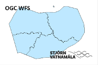
Opin gögn - Stjórn Vatnamála
(
WWW:LINK-1.0-http--link
)
Heimasíða með opinberum landupplýsingum sem tengast stjórn vatnamála á Íslandi.
- OnLine resource
- https://dservices1.arcgis.com/s4ES6RrX27tE99NO/arcgis/services/WFS_SubUnit_IS_20181222/WFSServer?service=wfs&request=getcapabilities ( OGC:WFS )
- OnLine resource
- WISE GIS guidance (v6.0.6 2016-04-29) ( WWW:LINK-1.0-http--related )
- OnLine resource
- Stjórn vatnamála ( WWW:LINK-1.0-http--partners )
- Hierarchy level
- Dataset
Conformance result
- Date ( Publication )
- 2010-12-08
- Explanation
- Validation has not been performed.
- Pass
- No
- Statement
- The data has been both topologically and attribute value verified and validated internally and conforms to all WISE GIS guidance requirements on the reporting of spatial data to WISE (v6.0.6).
gmd:MD_Metadata
- File identifier
- 54e40311-0a41-447c-9e21-629720fe6d98 XML
- Metadata language
- en
- Character set
- UTF8
- Hierarchy level
- Dataset
- Date stamp
- 2021-12-15T20:15:53
- Metadata standard name
- INSPIRE Metadata Implementing Rules
- Metadata standard version
- Technical Guidelines based on EN ISO 19115 and EN ISO 19119 (Version 1.2)
http://www.vedur.is.is/
Overviews
Spatial extent
Provided by
