 Lýsigagnagátt
GroundWaterBody IS 20181222
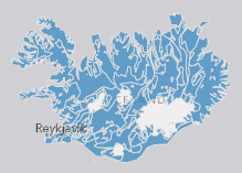
EN: Groundwaterbodies in Iceland as reported to WISE on 22.12.2018.
"Groundwater" means all water which is below the surface of the ground in the saturation zone and in direct contact with the ground or subsoil. For further description of dataset fields and field valuessee GML schema here: http://dd.eionet.europa.eu/schemas/WFD2016/GML_GroundWaterBody_2016.xsd
IS: Grunnvatnshlot á Íslandi miðað við skil inn í WISE upplýsingakerfið þann 22.12.2018.
"Grunnvatn" merkir vatn, kalt eða heitt, sem er neðan jarðar í samfelldu lagi, kyrrstætt eða rennandi, og fyllir að jafnaði allt samtengt holrúm í viðkomandi jarðlagi. Nánari lýsing á eigindum og gildum gagnasettsins má finna í GML skema hér.
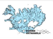
Um er að ræða grunnvatnshlot sem notuð eru til að gefa upp ástand vatns á Íslandi. Nánari lýsing á eigindum og gildum gagnasettsins má finna í GML skema hér:
http://dd.eionet.europa.eu/schemas/WFD2016/GML_GroundWaterBody_2016.xsd
Simple
- Date ( Publication )
- 2018-12-22
- Status
- Completed
- Maintenance and update frequency
- As needed
- Keywords
-
- INSPIRE
- Groundwaterbody
- water
- Grunnvatnshlot
- Grunnvatn
- Stjórn Vatnamála
- Priority dataset
- GSL
- Legislation Level ( Theme )
- Topic categories in accordance with EN ISO 19115 ( Theme )
-
- Inland Waters
- INSPIRE priority data set ( Theme )
- GEMET - INSPIRE themes, version 1.0 ( Theme )
- Use constraints
- Other restrictions
- Other constraints
- This work is licensed under a Creative Commons Attribution 4.0 International License (CC-BY)
- Access constraints
- Other restrictions
- Other constraints
- no limitations to public access
- Spatial representation type
- Vector
- Denominator
- 50000
- Metadata language
- en
- Character set
- UTF8
- Topic category
-
- Boundaries
))
- Reference system identifier
- http://www.opengis.net/def/crs/EPSG/0/4326
- Distribution format
-
-
GeoTIFF
(
1.0
)
-
KML
(
0
)
-
PNG
(
0
)
-
GML
(
3.2.1
)
-
ZIP
(
0
)
-
GeoTIFF
(
1.0
)
- OnLine resource
-
Eionet
(
WWW:LINK-1.0-http--link
)
Further information of data set fields and field values see GML schema
- OnLine resource
- Icelandic Met Office ( WWW:LINK-1.0-http--link )
- OnLine resource
- Opin gögn - Stjórn vatnamála ( WWW:LINK-1.0-http--link )
- OnLine resource
- https://dservices1.arcgis.com/s4ES6RrX27tE99NO/arcgis/services/WFS_GroundWaterBody_IS_20181222/WFSServer?service=wfs&request=getcapabilities ( OGC:WFS )
- OnLine resource
- Stjórn vatnamála ( WWW:LINK-1.0-http--link )
- OnLine resource
- WISE GISguidance (v6.0.6 2016-04-29) ( WWW:LINK-1.0-http--link )
- Hierarchy level
- Dataset
Conformance result
- Date ( Publication )
- 2010-12-08
- Explanation
- Validation has not been performed.
- Pass
- No
- Statement
-
Derived from the International Hydrogeological Map of Europe 1: 5.000.00. BGR, EGS, UNESCO (2008).
Credit: National Energy Authority of Iceland, The Environment Agency of Iceland.
The data has been both topologically and attribute value verified and validated internally and conforms to all WISE GIS guidance requirements on the reporting of spatial data to WISE (v6.0.6). This is the current official version (2018-12-22) of the data.
gmd:MD_Metadata
- File identifier
- 343e422e-2e53-4324-a999-c925b327aa72 XML
- Metadata language
- en
- Character set
- UTF8
- Hierarchy level
- Dataset
- Date stamp
- 2021-12-15T19:10:05
- Metadata standard name
- INSPIRE Metadata Implementing Rules
- Metadata standard version
- Technical Guidelines based on EN ISO 19115 and EN ISO 19119 (Version 1.2)
http://www.vedur.is/
Overviews
Spatial extent
Provided by
