 Lýsigagnagátt
environment
Type of resources
Available actions
Topics
INSPIRE themes
Keywords
Contact for the resource
Provided by
Years
Formats
Representation types
Update frequencies
status
Scale
-
Vinsamlega hafið samband við Umhverfisstofnun vegna nánari upplýsinga.
-
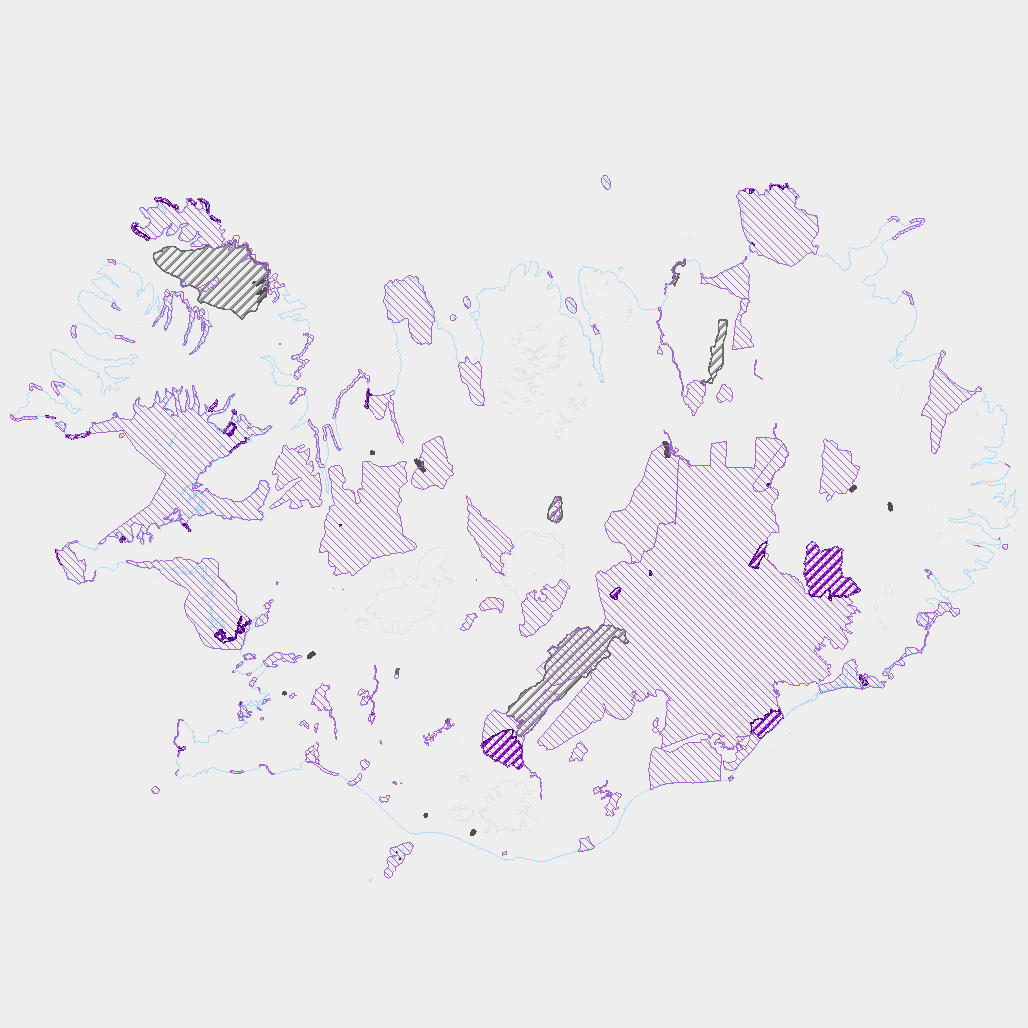
Þekja ni_tillogur_a_Bhluta_allt_fl: Tillögur að svæðum á framkvæmdaáætlun (B-hluta) náttúruminjaskrár út frá verndun vistgerða, fugla, sela, jarðminja og fossa. Innan stærri verndarsvæða voru í sumum tilfellum afmörkuð smærri svæði sem draga fram forgangsvistgerðir eða fuglategundir sem eru ekki einkennandi fyrir heildarsvæðið. Mörk eru ekki alltaf nákvæmlega skilgreind. Náttúruminjaskrá skiptist í þrjá hluta sem auðkenndir eru sem A, B og C-hluti. B-hluti er framkvæmdaáætlun náttúruminjaskrár þ.e. skrá yfir þær náttúruminjar sem Alþingi hefur ákveðið að setja í forgang um friðlýsingu eða friðun á næstu fimm árum. Í lögunum er lögð áhersla á að byggja upp skipulegt net verndarsvæða til að stuðla að vernd líffræðilegrar fjölbreytni, jarðbreytileika og fjölbreytni landslags. Náttúrufræðistofnun Íslands gerir tillögur um minjar sem ástæða þykir til að setja á framkvæmdaáætlun, þ.e. B-hluta. Að loknu því vali felur ráðherra Umhverfisstofnun að meta nauðsynlegar verndarráðstafanir á svæðum sem til greina kemur að setja á framkvæmdaáætlun og kostnað við þær. Í því ferli koma fram ýmsir aðrir hagsmunir sem geta haft áhrif á endanlegt val svæða en eru sem slíkir ekki grunnþættir í vali á svæðum til að viðhalda ákjósanlegri verndarstöðu vistgerða, vistkerfa eða tegunda. Að lokum mun Umhverfis-, orku- og loftslagsráðuneytið í samráði við ráðgjafanefnd leggja fram þingsályktunartillögu um verndun svæða. Tillögurnar eru enn í úrvinnslu hjá Umhverfisstofnun og umhverfis-, orku- og loftslagsráðherra (staða 23. febrúar 2022). Afmörkun svæða í tillögum Náttúrufræðistofnunar er ekki alltaf nákvæmlega skilgreind og getur tekið breytingum við áframhaldandi undirbúning framkvæmdaáætlunar.
-
Fráveituvatn er í eðli sínu notað vatn. Vatn sem við höfum nýtt til að baða okkur, elda mat, sturta niður í klósettin, þvo bíla, föt og ýmislegt annað. Notkunin veldur því að allskonar efni s.s. úrgangur frá fólki, matarleifar, olíur, sápur, hreinsiefni, málmar og jafnvel hættuleg efni blandast í annars hreint vatn. - Fráveituvatn getur verið mengunarvaldur en góð hreinsun getur dregið verulega úr neikvæðum áhrifum þess: - Úrgangur frá fólki er saurmengaður lífrænn úrgangur sem inniheldur bæði áburðarefni og mikið magn örvera og sýkla. - Í fráveituna berst ýmis úrgangur t.d. af yfirborði gatna og rusl (blautklútar, tannþráður o.fl.) sem er hent í í salerni. - Ýmis hættuleg efni s.s. úr hreinsiefnum, eldtefjandi efni og skordýraeitur geta fundist í fráveituvatni. - Mikið magn af næringarefnum (fosfór og köfnunarefni) í skólpi getur valdið ofauðgun eða aukinni framleiðslu þörunga (þörungablóma) sem getur leitt til skorts á súrefni í vatninu. Slíkt hefur neikvæð áhrif á staðbundið vatnalíf og getur valdið dauða ýmissa lífvera. - Fráveituvatn mengað af lyfjaleifum getur haft neikvæð áhrif á dýr, eins og fjölgun og hegðun þeirra. Losun sýklalyfja í skólpi eykur þróun lyfjaónæmis hjá bakteríum í umhverfinu. Best er að draga eins og hægt er úr allri efnanotkun og sturta ekki efnum í klósett og niðurföll heldur fara með þau til móttökuaðila slíks úrgangs.
-
Íslandi er skipt upp í loftgæðasvæði og bera heilbrigðiseftirlit viðkomandi svæða ábyrgð á því að ekki sé farið yfir mörk þar, og áætlunum um hvernig bregðast á við ef farið er yfir mörk.
-

Upplýsingar um gönguleiðir á friðslýstum svæðum. Fyrir frekari upplýsingar um gögnin er bent á að hafa samband við Umhverfisstofnun.
-

Gögnin sýna mörk veiðisvæða. Fyrir nánari upplýsingar um gögnin er bent á að hafa samband við Umhverfisstofnun.
-
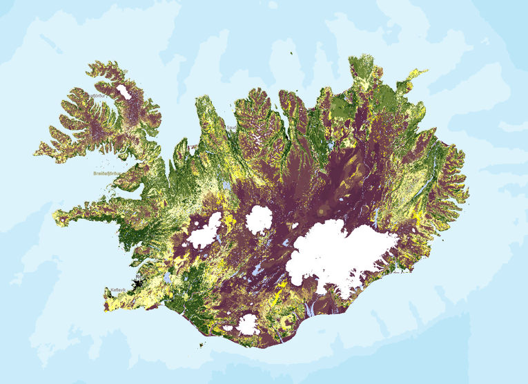
Stöðumat á ástandi gróður- og jarðvegsauðlinda Íslands. Landupplýsingaþekjan fyrir stöðumat Grólindar er á rastaformi. Nákvæmni gagna miðast við mælikvarða 1:100.000. Stöðumat GróLindar sýnir, á grófum kvarða, stöðu gróður- og jarðvegsauðlinda Íslands eins og hún er í dag. Stöðumatið er unnið upp úr kortlagningu vistgerðaflokka Náttúrufræðistofnunar Íslands frá 2016 og kortlagningu á jarðvegsrofi á vegum Rannsóknastofnunar landbúnaðarins og Landgræðslunni frá 1997. Landgræðslan og Skógræktin voru sameinaðar 1. janúar 2024 og ber stofnunin heitið Land og skógur. Frekari upplýsingar um aðferðafræðina á bak við stöðumatið má sjá í ritinu: Bryndís Marteinsdóttir, Elín Fjóla Þórarinsdóttir, Guðmundur Halldórsson, Jóhann Helgi Stefánsson, Jóhann Þórsson, Kristín Svavarsdóttir, Magnús Þór Einarsson, Sigþrúður Jónsdóttir og Sigmundur Helgi Brink, 2020. Stöðumat á ástandi gróður- og jarðvegsauðlinda Íslands. Aðferðafræði og faglegur bakgrunnur. Rit Landgræðslunnar nr. 3. Gunnarsholt, Ísland. https://grolind.is/wp-content/uploads/2020/06/GroLind_stodumat_18_06_2020.pdf
-
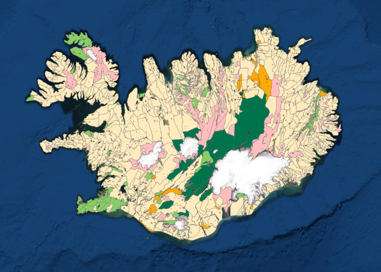
Kortlagning beitarlanda sauðfjár á Íslandi. Landupplýsingaþekjan fyrir beitarlönd sauðfjár er á vektorformi. Nákvæmni gagna miðast við mælikvarða 1:100.000. Frekari upplýsingar um aðferðafræðina á bak við kortlagningu beitarlanda sauðfjár má sjá í ritinu: : Jóhann Helgi Stefánsson, Sigríður Þorvaldsdóttir, Iðunn Hauksdóttir, Elín Fjóla Þórarinsdóttir, Bryndís Marteinsdóttir og Sigmundur Helgi Brink, 2020. Kortlagning beitarlanda sauðfjár á Íslandi. Rit Landgræðslunnar nr. 4. Gunnarsholt, Ísland. https://grolind.is/wp-content/uploads/2020/06/Kortlagning-beitilanda-2020.pdf Landgræðslan og Skógræktin voru sameinaðar 1. janúar 2024 og ber stofnunin heitið Land og skógur.
-

Hér eru að finna upplýsingar um svæði sem falla undir verndarflokk rammaáætlunar og eru friðlýst á grundvelli gildandi þingsályktana um áætlun um vernd og orkunýtingu landsvæða skv. lögum nr. 48/2011 um verndar- og orkunýtingaráætlun og 53. gr. laga um náttúruvernd nr. 60/2013.Vinsamlegast hafið sambandi við Umhverfisstofnun fyrir nánari upplýsingar.
-
Vinsamlega hafið samband við Umhverfisstofnun vegna nánari upplýsinga.