 Lýsigagnagátt
boundaries
Type of resources
Available actions
Topics
INSPIRE themes
Keywords
Contact for the resource
Provided by
Years
Formats
Representation types
Update frequencies
status
Scale
Resolution
-

EuroBoundaryMap is a seamless geo-database at the scale 1:100 000 covering 55 countries. It contains geometry, names and codes of administrative and statistical units continuously updated by the members of EuroGeographics, the national mapping and cadastral authorities (NMCAs) of Europe. Updated annually. Datasets in EBM: The EBM dataset was derived from the Icelandic National Database IS 50V, which is at the scale 1:50.000. The generalization has been applied in form of smooth polygon and simplify polygon that ensured the required resolution of the data for the EBM 1: 100 000 scale. The topological relations of the line and area features were ensured. Administrative Units includes: AdministrativeBoundary a line layer containing the demarcations outlining administrative units. AdministrativeUnit_1 a polygon layer containing the national administrative hierarchy, Level 1 (republic). AdministrativeUnit_2 a polygon layer containing the national administrative hierarchy, Level 2 (municipalities). Residence of Authority a point layer containing the administrative centres of all administrative levels. BasicGeometry includes: EBM_A a polygon layer containing administrative areas. Here are the basic components on which administrative units of all hierarchical levels, as well as all statistical layers, are composed. EBM_P a point layer meant for labelling purposes. Label points are located within the main area of the administrative units on lowest level. StatisticalUnits includes: LAU a polygon layer = Local Administrative Unit. NUTS_1 a polygon layer = Nomenclature of Territorial Units for Statistics (whole country) NUTS_2 a polygon layer NUTS_3 a polygon layer = Nomenclature of Territorial Units for Statistics (capital area, rural areas) Tables in EBM: CountryCodes = all countries have unique country codes (icc). EBM_CHR = country codes of those countries where the language is used in alphabetical order delimited by #. EBM_coAdministered = Relationship between administrative unit and its co-administering administrative units on the same hierarchical level. A few countries have special areas with shared administrative units. EBM_ISN = designations of administrative hierarchical levels EBM_NAM = names of administrative units EBM_NUTS = Relationship between the SHN codes of administrative units on lowest national administrative level and corresponding statistical codes.
-

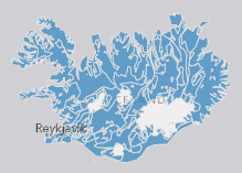
Þekjan sýnir orkuspársvæði sem koma fram í orkuspá Orkustofnunar. Það eru svæðin Suðurnes, Reykjavík, Vesturland, Vestfirðir, Norðurland, Austurland og Suðurland. Svæðin eru aðeins öðruvísi en í hefðbundinni landshlutaskiptingu þar sem sú skipting er til komin vegna uppbyggingar flutningskerfisins.
-

Boundaries of various areas within Vatnajökull National Park with special rules. 1. Esjufjöll, Jökulsárgljúfur, Skaftafell and Askja have special rules about camping restrictions, according to article 3, in regulation about Vatnajökull National Park, 300/2020. Coordinates are listed in table 2 in amendment IV in the regulation. 2. Hvannadalshnjúkur, Öræfajökull and Kverkfjöll have special limitations on, if and when motorized traffic is allowed. 3. Traditional land use areas are listed in article 26 of regulation about Vatnajökull National Park, 300/2020. Disclaimer: If there is a difference between the data and the regulation text, then the regulation text applies.
-

Riparian zones represent transitional areas occurring between land and freshwater ecosystems, characterised by distinctive hydrology, soil and biotic conditions and strongly influenced by the stream water. They provide a wide range of riparian functions (e.g. chemical filtration, flood control, bank stabilization, aquatic life and riparian wildlife support, etc.) and ecosystem services. The Riparian Zones products will support the objectives of several European legal acts and policy initiatives, such as the EU Biodiversity Strategy to 2020, the Habitats and Birds Directives and the Water Framework Directive. Land Cover/Land Use (LC/LU) classification is tailored to the needs of biodiversity monitoring in a tailored buffer zone along large and medium-sized European rivers (with Strahler levels 3-8 derived from EU-Hydro). LC/LU is extracted from VHR satellite data and other available data in a buffer zone of selected rivers. The classes follow the pre-defined nomenclature on the basis of MAES typology of ecosystems (Level 1 to Level 4) and Corine Land Cover, providing 80 distinct thematic classes with a Minimum Mapping Unit (MMU) of 0.5 ha and a Minimum Mapping Width (MMW) of 10 m. The production of the Riparian Zones products was coordinated by the European Environment Agency in the frame of the EU Copernicus programme.
-

Línurnar sýna friðunarsvæði, þar sem eldi laxfiska (fam. salmonidae) í sjókvíum er óheimilt skv. auglýsingu nr. 460/2004.
-
EN: Groundwaterbodies in Iceland as reported to WISE on 22.12.2018. "Groundwater" means all water which is below the surface of the ground in the saturation zone and in direct contact with the ground or subsoil. For further description of dataset fields and field valuessee GML schema here: http://dd.eionet.europa.eu/schemas/WFD2016/GML_GroundWaterBody_2016.xsd IS: Grunnvatnshlot á Íslandi miðað við skil inn í WISE upplýsingakerfið þann 22.12.2018. "Grunnvatn" merkir vatn, kalt eða heitt, sem er neðan jarðar í samfelldu lagi, kyrrstætt eða rennandi, og fyllir að jafnaði allt samtengt holrúm í viðkomandi jarðlagi. Nánari lýsing á eigindum og gildum gagnasettsins má finna í GML skema hér. Um er að ræða grunnvatnshlot sem notuð eru til að gefa upp ástand vatns á Íslandi. Nánari lýsing á eigindum og gildum gagnasettsins má finna í GML skema hér: http://dd.eionet.europa.eu/schemas/WFD2016/GML_GroundWaterBody_2016.xsd
-

Landinu skal skipt upp í eftirfarandi heilbrigðisumdæmi, sbr. reglugerð 387/2015: Heilbrigðisumdæmi höfuðborgarsvæðisins. Heilbrigðisumdæmi Vesturlands. Heilbrigðisumdæmi Vestfjarða. Heilbrigðisumdæmi Norðurlands. Heilbrigðisumdæmi Austurlands. Heilbrigðisumdæmi Suðurlands. Heilbrigðisumdæmi Suðurnesja. Í heilbrigðisumdæmum landsins starfa eftirfarandi heilbrigðisstofnanir: Heilsugæsla höfuðborgarsvæðisins, innan heilbrigðisumdæmis höfuðborgarsvæðisins. Heilbrigðisstofnun Vesturlands, innan heilbrigðisumdæmis Vesturlands. Heilbrigðisstofnun Vestfjarða, innan heilbrigðisumdæmis Vestfjarða. Heilbrigðisstofnun Norðurlands, innan heilbrigðisumdæmis Norðurlands. Heilbrigðisstofnun Austurlands, innan heilbrigðisumdæmis Austurlands. Heilbrigðisstofnun Suðurlands, innan heilbrigðisumdæmis Suðurlands. Heilbrigðisstofnun Suðurnesja, innan heilbrigðisumdæmis Suðurnesja.
-

Eftirfarandi landshlutar eru sóttvarnaumdæmi, sbr. reglugerð 387/2015: Höfuðborgarsvæðið (Reykjavíkurborg, Seltjarnarnesbær, Kópavogsbær, Garðabær, Hafnarfjarðarkaupstaður, Mosfellsbær, Kjósarhreppur og fyrrum sveitarfélagið Þingvallasveit). Vesturland (Akraneskaupstaður, Hvalfjarðarsveit, Skorradalshreppur, Borgarbyggð, Eyja- og Miklaholtshreppur, Snæfellsbær, Grundarfjarðarbær, Helgafellssveit, Stykkishólmsbær, Dalabyggð, Reykhólahreppur, Strandabyggð, Kaldrananeshreppur, Árneshreppur og Húnaþing vestra). Vestfirðir (Vesturbyggð, Tálknafjarðarhreppur, Ísafjarðarbær, Bolungarvíkurkaupstaður og Súðavíkurhreppur). Norðurland (Húnavatnshreppur, Blönduósbær, Skagabyggð, Sveitarfélagið Skagaströnd, Sveitarfélagið Skagafjörður, Akrahreppur, Fjallabyggð, Dalvíkurbyggð, Hörgársveit, Eyjafjarðarsveit, Akureyrarkaupstaður, Svalbarðsstrandarhreppur, Grýtubakkahreppur, Þingeyjarsveit, Norðurþing, Tjörneshreppur, Skútustaðahreppur, Svalbarðshreppur og Langanesbyggð að frátöldum fyrrum Skeggjastaðahreppi). Austurland (Vopnafjarðarhreppur, Fljótsdalshérað, Fljótsdalshreppur, Borgarfjarðarhreppur, Seyðisfjarðarkaupstaður, Fjarðabyggð, Breiðdalshreppur, Djúpavogshreppur og fyrrum Skeggjastaðahreppur). Suðurland (Sveitarfélagið Ölfus, Hveragerðisbær, Grímsnes- og Grafningshreppur, Bláskógabyggð að frátöldu fyrrum sveitarfélaginu Þingvallasveit, Hrunamannahreppur, Sveitarfélagið Árborg, Flóahreppur, Ásahreppur, Skeiða- og Gnúpverjahreppur, Rangárþing ytra, Rangárþing eystra, Mýrdalshreppur, Skaftárhreppur, Sveitarfélagið Hornafjörður og Vestmannaeyjabær). Suðurnes (Sandgerðisbær, Sveitarfélagið Garður, Reykjanesbær, Grindavíkurbær og Sveitarfélagið Vogar).
-
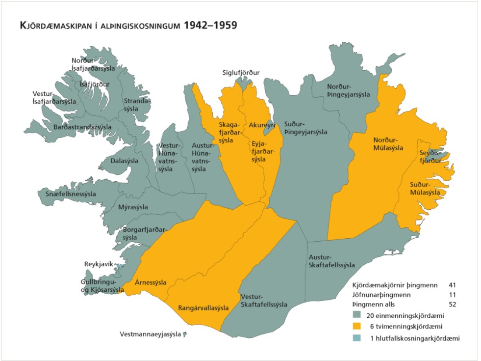
Kjördæmi eru afmörkuð landsvæði sem mynda einn af grunnþáttum kosningakerfisins. Framboðslistar eru lagðir fram fyrir hvert og eitt kjördæmi þannig að kjósendur í sama kjördæminu geta valið á milli sömu framboðslistanna og kjörnir fulltrúar hljóta þar umboð sitt til þingsetu. Kjördæmaskipulagið og fjöldi kjósenda í hverju þeirra liggur til grundvallar þegar þingsætum er úthlutað eftir þingkosningar. Þar sem kjördæmaskipulagið er ráðandi fyrir vægi atkvæða kjósenda hefur það mikil áhrif á það hvaða frambjóðendur fá sæti á þingi að loknum kosningum. Kjördæmaskipulagið er því meðal þess sem oft hefur orðið að deiluefni. Þegar gerðar voru á því verulegar breytingar kostuðu þær jafnan pólitísk átök og allar hafa þær þýtt málamiðlanir milli ólíkra sjónarmiða. Tekið af vef Alþingis: https://www.althingi.is/thingmenn/althingiskosningar/kosningar-og-kosningaurslit/kjordaemaskipulagid/
-

The combined Water and Wetness product is a thematic product showing the occurrence of water and wet surfaces over the period from 2009 to 2015. Two products are available: o The main Water and Wetness (WAW) product with defined classes of (1) permanent water, (2) temporary water, (3) permanent wetness and (4) temporary wetness. o The additional expert product: Water & Wetness Probability Index (WWPI) The products show the occurrence of water and indicate the degree of wetness in a physical sense, assessed independently of the actual vegetation cover and are thus not limited to a specific land cover class and their relative frequencies. A verification of the Water and Wetness layer was performed by the Institute of Nature Research during autumn of 2018 and the data and resulting report are made available on the NLSI websites.