 Lýsigagnagátt
european
Type of resources
Available actions
Topics
INSPIRE themes
Keywords
Contact for the resource
Provided by
Formats
Representation types
Update frequencies
status
Scale
-
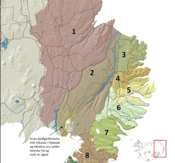
Árlega eru felld um 1.500 hreindýr á Íslandi til að stjórna stofnstærð. Hver fellipunktur er skráður í kerfi Umhverfisstofnunar.
-
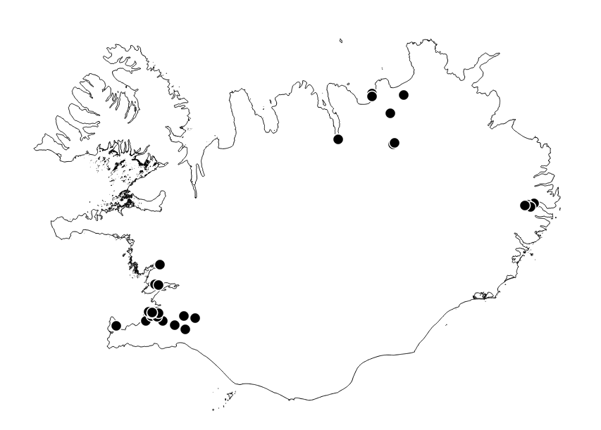
Staðsetningar loftmælistöðva á Íslandi. Umhverfisstofnun skilar árlega loftgæðaskýrslum til Evrópsku umhverfisstofnunarinnar (EEA) og uppfylla þau gögn INSPIRE-tilskipanir varðandi flokkun stöðva. Rekstraraðilar geta breytt gögnum stöðva.
-
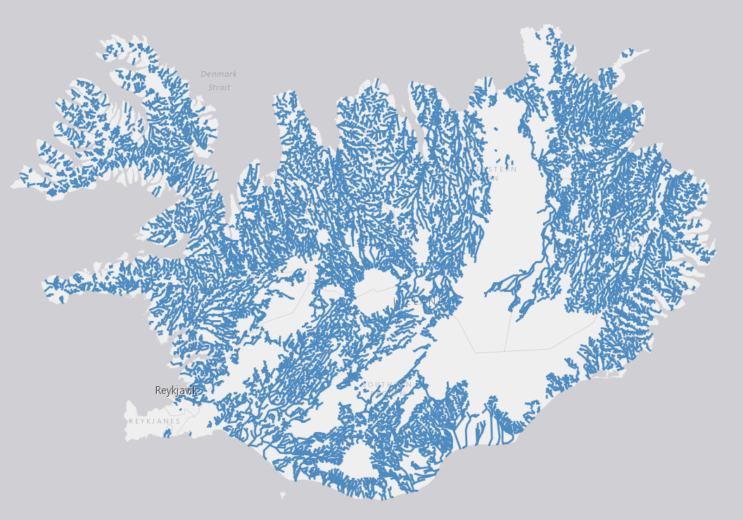
EN: River waterbodies in Iceland as reported to WISE on 22.12.2018. "River" means a body of inland water flowing for the most part on the surface of the land but which may flow underground for part of its course.For further description of dataset fields and field values see GML schema here: http://dd.eionet.europa.eu/schemas/WFD2016/GML_SurfaceWaterBodyLine_2016.xsd IS: Straumvatnshlot á Íslandi miðað við skil inn í WISE upplýsingakerfið þann 22.12.2018. Straumvatn er vatnsfall sem flæðir eftir og á yfirborði lands að mestu en getur að hluta til flætt neðanjarðar. Nánari lýsing á eigindum og gildum gagnasettsins má finna í GML skema hér: http://dd.eionet.europa.eu/schemas/WFD2016/GML_SurfaceWaterBodyLine_2016.xsd
-
EN: Boundary of River Basin District(s) of Iceland as reported to WISE on 22.12.2018."River basin district" means the area of land and sea, made up of one or more neighbouring river basins together with their associated groundwaters and coastal waters, which is identified under Article 3(1) as the main unit for management of river basins.For further description of dataset fields and field values see GML schema here. http://dd.eionet.europa.eu/schemas/WFD2016/GML_RiverBasinDistrict_2016.xsd IS: Vatnaumdæmi Íslands miðað við skil inn í WISE upplýsingakerfið þann 22.12.2018. Vatnaumdæmi er stjórnsýslueining sem nær til íslenskra vatnasvæða ásamt árósavatni og strandsjó sem þeim tengjasteins og það er skilgreint í lögum nr. 35/2011 og reglugerð nr.935/2011 um Stjórn vatnamála. Nánari lýsing á eigindum og gildum gagnasettsins má finna í GML skema hér: http://dd.eionet.europa.eu/schemas/WFD2016/GML_RiverBasinDistrict_2016.xsd
-
EN: Boundary of Icelandic River Basin Sub unit(s) as reported to WISE on 22.12.2018. A "Sub unit" is a defined area that includes one or more catchments. For international reporting purposes only one Sub unit is used (ID: IS100) which covers the same area as the Icelandic River Basin District. For national management and reporting purposes there are four Sub Units (ID's: IS101, IS102, IS103, IS104). For further description of dataset fields and field values see GML schema here: http://dd.eionet.europa.eu/schemas/WFD2016/GML_SubUnit_2016.xsd IS: Afmörkun íslenskra vatnasvæða miðað við skil inn í WISE upplýsingakerfið þann 22.12.2018. "Vatnasvæði" er landsvæði með einu eða fleiri vatnasviðum. Vegna skýrslugjafar til Evrópusambandsins er aðeins eitt vatnasvæði notað (ID:IS100) sem nær yfir sama svæði og Vatnaumdæmi Íslands. Vegna innlendrar stjórnunar og skýrslugjafar eru fjögur vatnasvæði notuð (IDs: IS101, IS102, IS103, IS104). Nánari lýsing á eigindum og gildum gagnasettsins má finna í GML skema hér: http://dd.eionet.europa.eu/schemas/WFD2016/GML_SubUnit_2016.xsd
-
EN: Groundwaterbodies in Iceland as reported to WISE on 22.12.2018. "Groundwater" means all water which is below the surface of the ground in the saturation zone and in direct contact with the ground or subsoil. For further description of dataset fields and field valuessee GML schema here: http://dd.eionet.europa.eu/schemas/WFD2016/GML_GroundWaterBody_2016.xsd IS: Grunnvatnshlot á Íslandi miðað við skil inn í WISE upplýsingakerfið þann 22.12.2018. "Grunnvatn" merkir vatn, kalt eða heitt, sem er neðan jarðar í samfelldu lagi, kyrrstætt eða rennandi, og fyllir að jafnaði allt samtengt holrúm í viðkomandi jarðlagi. Nánari lýsing á eigindum og gildum gagnasettsins má finna í GML skema hér. Um er að ræða grunnvatnshlot sem notuð eru til að gefa upp ástand vatns á Íslandi. Nánari lýsing á eigindum og gildum gagnasettsins má finna í GML skema hér: http://dd.eionet.europa.eu/schemas/WFD2016/GML_GroundWaterBody_2016.xsd
-
EN: Lake and coastal waterbodies in Iceland. "Lake" means a body of standing inland surface water. "Coastal water" means surface water on the landward side of a line, every point of which is at a distance of one nautical mile on the seaward side from the nearest point of the baseline from which the breadth of territorial waters is measured, extending where appropriate up to the outer limit of transitional waters. For further description of dataset fields and field values see GML schema here: http://dd.eionet.europa.eu/schemas/WFD2016/GML_SurfaceWaterBody_2016.xsd IS:Stöðuvatns- og strandsjávarhlot á Íslandi. "Stöðuvatn" er kyrrstætt yfirborðsvatn. "Strandsjór" er yfirborðsvatn landmegin við línu sem dregin er einni sjómílu utan grunnlínu landhelginnar og nær inn að ytri mörkum árósavatns. Nánari lýsing á eigindum og gildum gagnasettsins má finna í GML skema hér: http://dd.eionet.europa.eu/schemas/WFD2016/GML_SurfaceWaterBody_2016.xsd
-

ELF Protected Sites (PS) is one of 12 themes in the European Location Project (ELF). The purpose of ELF is to create harmonised cross-border, cross-theme and cross-resolution pan-European reference data from national contributions. The goal is to provide INSPIRE-compliant data for Europe. A description of the ELF (European Location Project) is here: http://www.elfproject.eu/content/overview. Encoding: INSPIRE version 4