 Lýsigagnagátt
Geology
Type of resources
Available actions
Topics
INSPIRE themes
Keywords
Contact for the resource
Provided by
Years
Formats
Representation types
Update frequencies
status
Service types
Scale
-
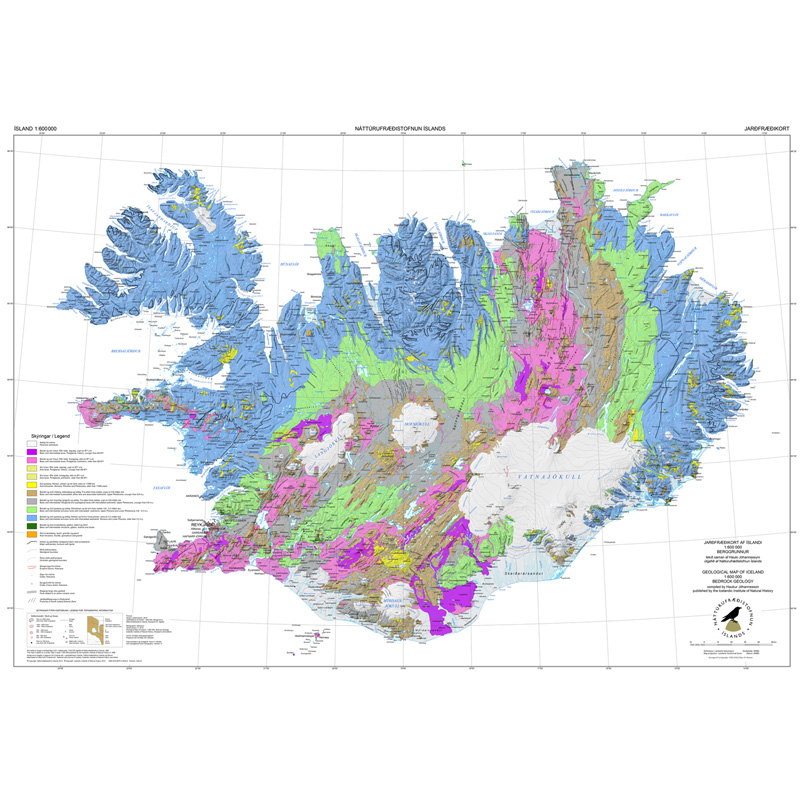
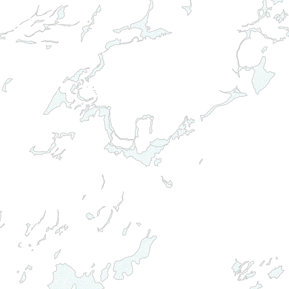
Gagnasafn (GDB) NI_J600v_berg_2.utg: Jarðfræðikorti af Íslandi – Berggrunnur – 1:600.000 [Geological Map of Iceland – Bedrock geology – 1:600.000]. Berggrunnskort af Íslandi sýnir stærstu drættina í jarðfræði landsins. Jarðlög eru flokkuð eftir aldri, gerð og samsetningu. Kortið sýnir vel gosbelti landsins og dreifingu gossstöðva frá nútíma. Nútímahraunum er skipt í forsöguleg og söguleg hraun (yngri en 871 e. Kr. ). [The Geological Map of Iceland shows the main features of the bedrock geology. Formation are classified by age, type, and composition. The map clearly shows the island's volcanic zones and the distribution of the recent eruption sites. Lava fields of the Holocene are shown as pre-historic or historic (younger than AD 871].]
-

Gagnasafn (GDB) NI_J600v_hoggun: Jarðfræðikorti af Íslandi – Höggun – 1:600.000 [Geological Map of Iceland – Tectonics – 1:600.000]. Höggunarkort af Íslandi sýnir jarðfræði landsins á nýstárlegan hátt. Jarðlög eru flokkuð eftir aldri en ekki eftir gerð og samsetningu. Sýnd eru eldstöðvakerfi, þ.e. megineldstöðvar, sprungu- og gangareinar, bæði virkar og útkulnaðar. Einnig eru sýnd helstu brotakerfi landsins og halli jarðlaga. Kortið gefur innsýn í jarðfræðilega byggingu landsins. [The Tectonic Map of Iceland gives a new view of the country's geology. The rocks are classified by age, but not by type or composition. Volcanic systems including central volcanoes, fissures and dyke swarms, both active and extinct, are shown, as are the island's principal fracture zones and the dip of rock layers. The map thus gives a useful insight into the geological structure of the country.]
-
Þekja [layer] j100v_vesturgosbelti_berggrunnurNidurfoll_1utg_fl: Niðurföll í nútímahraunum. [Collapse pits in Holocene lavas.}
-
Þekja [layer] j100v_vesturgosbelti_berggrunnur_1utg_li: Línur sýna viss og óviss mörk berggrunns og hraunjaðars ásamt hrauntröðum. [Lines showing certain and uncertain boundaries of bedrock and borders of lava fields, including lava channels.] Mörk tilheyra flákagögnum 'ni_j100v Berggrunnur á Vesturgosbelti – 1:100.000' (þekja j100v_vesturgosbelti_berggrunnur_1utg_fl). Nýr kóði fyrir fitjueigindina 'Jarðmyndun og landmótun lausra jarðefna' (jardmLandmJardefna): hram05 = hrauntröð brún. [Boundaries follow the polygon data 'ni_j100v Berggrunnur á Vesturgosbelti – 1:100.000' (layer j100v_vesturgosbelti_berggrunnur_1utg_fl). New code for feature attribute 'Jarðmyndun og landmótun lausra jarðefna' (jardmLandmJardefna): hram05 = lava channel edge.]
-
Þekja [layer] j100v_vesturgosbelti_gigar_1utg_p: Gervigígar, punktalag. [Rootless cones, point data.]
-
Þekja [layer] j100v_vesturgosbelti_jardgrunnur_1utg_fl: Jarðgrunnsgögn af Vesturgosbelti Íslands. [Surface deposits of the Western Volcanic Zone of Iceland.] Laus setlög, svo sem jökulgarðar og árset. [Unconsolidated sediments including glacial morianes and river sediments.]
-
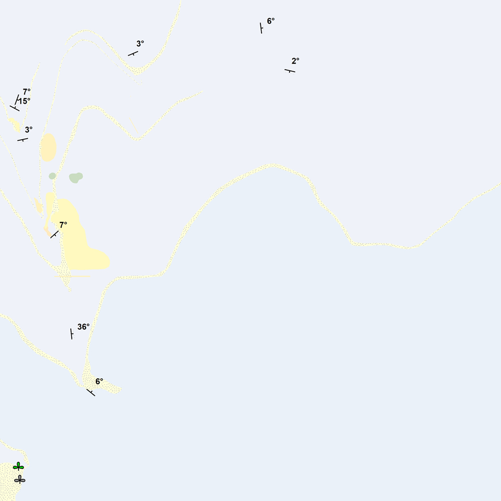
Þekja [layer] j100v_vesturgosbelti_berggrunnur_1utg_p: Steingervingar og strik og halli. [Fossils and strike and dip.] Gögnin innihalda halli, strík og hallaáttir ásamt þekktum steingervingum. Stríkstefna (fitjueigindi 'strikstefna'): 0-359° - fylgir 'right-hand rule'. Hallastefnu eru +90° frá stríksetfna. [The data includes dip, strike and dip directions along with known fossil locations. Strike direction (feature attribute 'strikstefna') follows the right-hand rule where dip direction is +90° from strike.]
-
Niðurhalsþjónustur LBHÍ
-
Þekja [layer] j100v_vesturgosbelti_hoggun_1utg_li: Höggun á Vesturgosbelti Íslands, línulag. [Tectonic of the Western Volcanic Zone Icelands, line features.] Gögn sýna sprungur, misgengi, gjár, mislægi og brotalínur, kortlagt í mkv. 1:100.000. [Tectonic line features such as faults, fractures, fissures, unconformity, and fracture lines mapped at 1:100,000 scale.]
-
Niðurhalsþjónustur Orkustofnunar