 Lýsigagnagátt
GeoPackage
Type of resources
Available actions
Topics
INSPIRE themes
Keywords
Contact for the resource
Provided by
Years
Formats
Representation types
Update frequencies
status
Scale
-
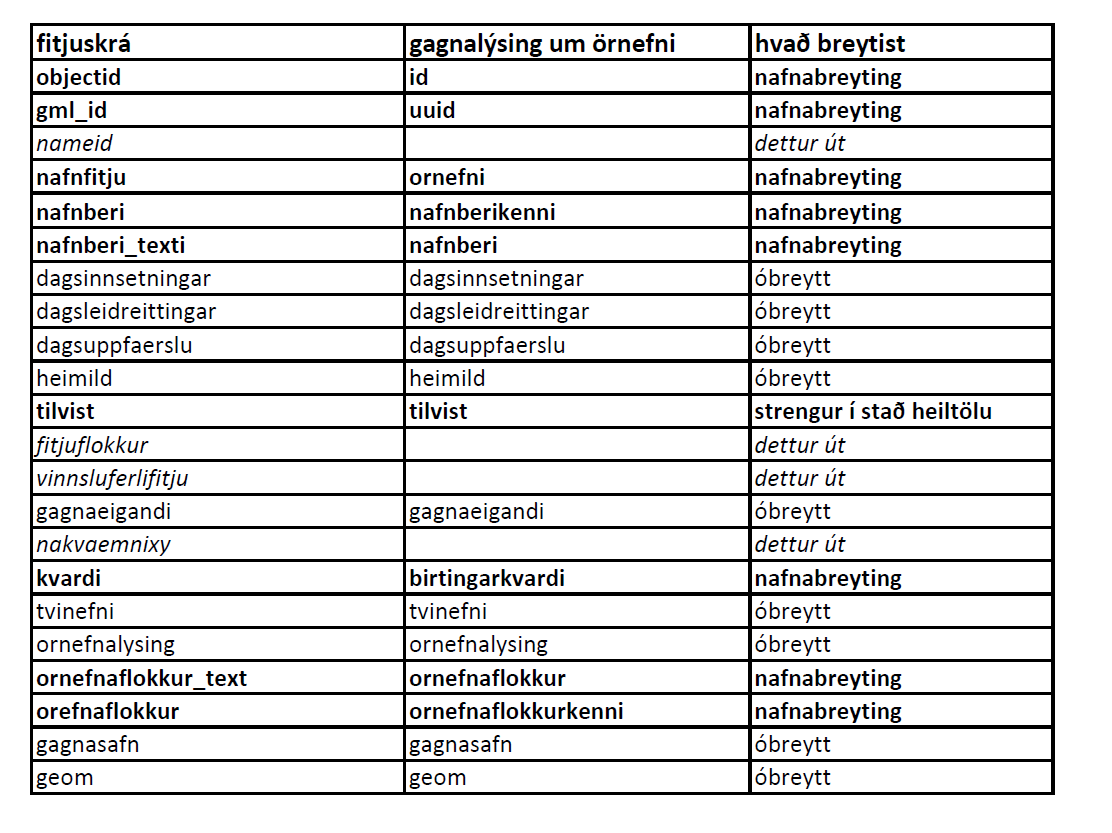
Örnefni eru í þremur lögum: flákalag, punktalag og línulag. Uppfærð örnefni birtast vikulega í vefsjám.
-

Strandlínulagið inniheldur bæði línu- og flákalag og er strandlína landsins sýnd auk eyja og skerja.Í fitjuklasanum is50v_strandlina_linur er strandlína landsins, eyja og skerja sýnd. Hægt er að sjá hvort línan tilheyrir eyjum eða skerjum. Í laginu is50v_strandlina_flakar er strandlína landsins, eyja og skerjar sýnd.
-

Vatnafarið skiptist í þrjú lög: línur, fláka og punkta.
-

This data includes all defined hiking trails within Vatnajökull National Park, and selected trails near the park. The trails are drawn from hiking maps that the park has published since it was founded in 2008. The maps have been updated regularly since, last update was in 2019, (Snæfell area and a large part of the western region). These hiking maps can be viewed by selecting “Hiking map, click on frame” in the Vatnajökull National Park Mapview, (see link below).
-

Abstract is not available in english
-

Boundaries of various areas within Vatnajökull National Park with special rules. 1. Esjufjöll, Jökulsárgljúfur, Skaftafell and Askja have special rules about camping restrictions, according to article 3, in regulation about Vatnajökull National Park, 300/2020. Coordinates are listed in table 2 in amendment IV in the regulation. 2. Hvannadalshnjúkur, Öræfajökull and Kverkfjöll have special limitations on, if and when motorized traffic is allowed. 3. Traditional land use areas are listed in article 26 of regulation about Vatnajökull National Park, 300/2020. Disclaimer: If there is a difference between the data and the regulation text, then the regulation text applies.
-

Vatnajökull National Park was founded on June 7th 2008, although the act on Vatnajökull National Park was entered into force on May 1st 2007. It is the largest national park in Iceland by far, 14,967 km2. Vatnajökull National Park was inscribed as a UNESCO World Heritage Site on July 5th 2019. The boundary of Vatnajökull National Park, after its latest expansion on September 22nd 2021. The boundary is drawn in accordance to regulation on Vatnajökull National Park, No 300/2020, with later amendments. Disclaimer: If there is a difference between the data and the regulation text, then the regulation text applies. The data also includes all previous boundaries of the national park as well as current boundaries of operating areas.
-
Hæðargögnin innhalda bæði línu- og punktalag.Í laginu is50v_haedarlinur eru sýndar hæðarlínur 20 metra og 100 metra hæðarlínur. Á fáeinum stöðum er að finna viðbótar 10 metra hæðarlínur.
-

Yfirborðið er einfaldað flákalag úr CORINE-verkefninu sem sýnir gróin og ógróin svæði, skipulögð svæði og vatnafar (stærstu svæðin sem lenda undir vatni).
-

Gögnin sýna útlínur hrauns frá Heklugosunum árin 1947-1948, 1970, 1980-1981, 1991 og 2000 af uppréttum loftmyndum sem teknar voru eftir hvert eldgos. Nánari upplýsingar er að finna í grein Pedersen o.fl., 2018 (https://agupubs.onlinelibrary.wiley.com/doi/full/10.1002/2017GL076887) Tilvísun: Pedersen, G. B. M., Belart, J. M. C., Magnússon, E., Vilmundardóttir, O. K., Kizel, F., Sigurmundsson, F. S., et al. (2018). Hekla volcano, Iceland, in the 20th century: Lava volumes, production rates, and effusion rates. Geophysical Research Letters, 45, 1805–1813. https://doi.org/10.1002/2017GL076887 ---- The lava outlines from the eruptions of Hekla in 1947-1948, 1970, 1980-1981, 1991 and 2000, digitized from orthorrectified aerial photographs acquired after each eruption. Details of these data are available in Pedersen et al., 2018 (https://agupubs.onlinelibrary.wiley.com/doi/full/10.1002/2017GL076887) Reference: Pedersen, G. B. M., Belart, J. M. C., Magnússon, E., Vilmundardóttir, O. K., Kizel, F., Sigurmundsson, F. S., et al. (2018). Hekla volcano, Iceland, in the 20th century: Lava volumes, production rates, and effusion rates. Geophysical Research Letters, 45, 1805–1813. https://doi.org/10.1002/2017GL076887