 Lýsigagnagátt
ESRI ArcGIS File Geodatabase
Type of resources
Available actions
Topics
INSPIRE themes
Keywords
Contact for the resource
Provided by
Years
Formats
Representation types
Update frequencies
status
Scale
-
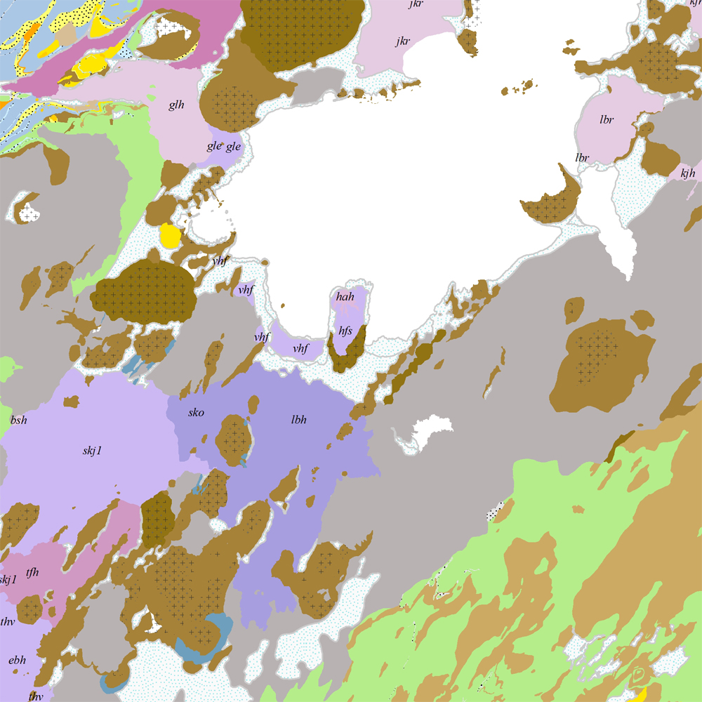
Þekja [layer] j100v_vesturgosbelti_berggrunnur_1utg_fl: Gögn fyrir berggrunn ásamt nútímahraunum. [Data showing the bedrock geology, including Holocene lavas.] Berggrunnur er flokkaður eftir aldri, gerð og samsetningu. Gögn eru flokkuð eftir ÍST120:2012 staðlinum, nema fitjueigindir: myndunKodi = stuttur kóði sem táknar gerð bergmyndunar, myndunIS = stutt íslenskt heiti fyrir bergmyndun, myndunEN = stutt enskt nafn á bergmyndun, eldstodNafn = nafn eldstöðvakerfis, kenni = stuttur kóði fyrir hlýskeiðishraun og nútímahraun, aldur = aldursbil, Nýr kóði fyrir fitjueigindina 'Tegund storkubergs' (tegStorkubergs): dbas = dílabasalt. [Bedrock is classified by age, type, and composition. The data follows the ÍST120:2012 data standard with these additional feature attributes: myndunKodi = short code denoting the rock formation type, myndunIS = short Icelandic name for rock formation, myndunEN = short English name for rock formation, eldstodNafn = name of the volcanic system, kenni = short codename for interglacial and postglacial lavas, aldur = age range. New code for feature attribute 'Tegund storkubergs' (tegStorkubergs): dbas = porphyrytic basalt.]
-
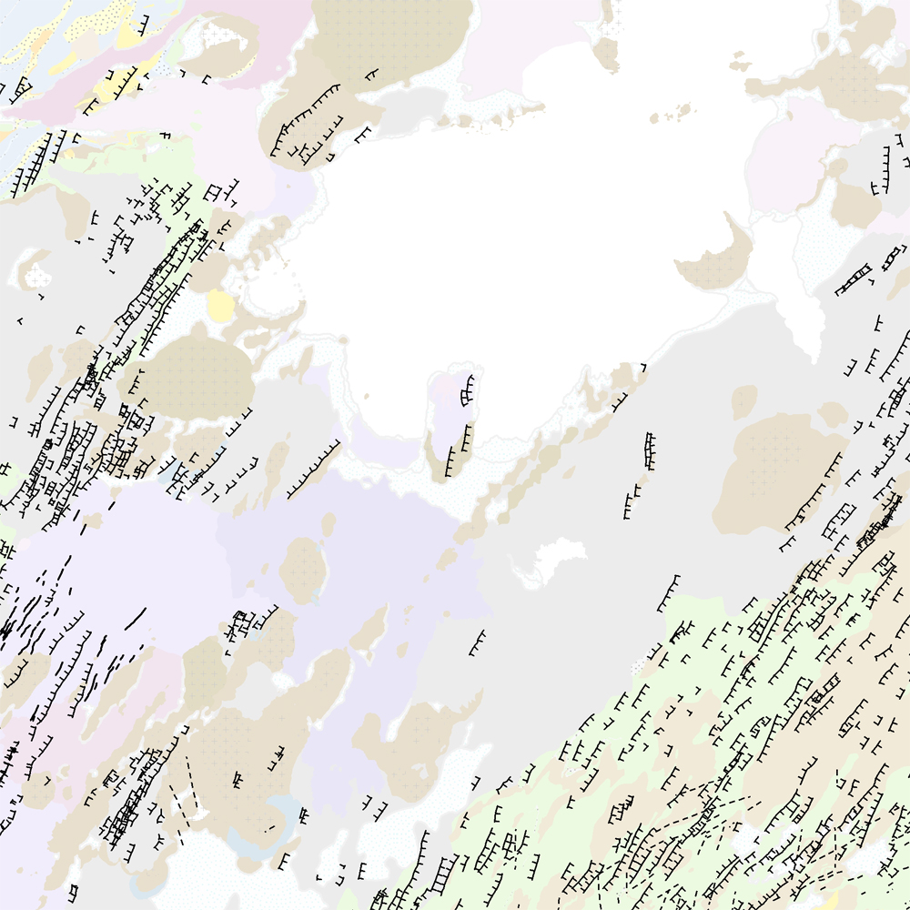
Þekja [layer] j100v_vesturgosbelti_hoggun_1utg_li: Höggun á Vesturgosbelti Íslands, línulag. [Tectonic of the Western Volcanic Zone Icelands, line features.] Gögn sýna sprungur, misgengi, gjár, mislægi og brotalínur, kortlagt í mkv. 1:100.000. [Tectonic line features such as faults, fractures, fissures, unconformity, and fracture lines mapped at 1:100,000 scale.]
-
Þekja [layer] j100v_vesturgosbelti_berggrunnurNidurfoll_1utg_fl: Niðurföll í nútímahraunum. [Collapse pits in Holocene lavas.}
-
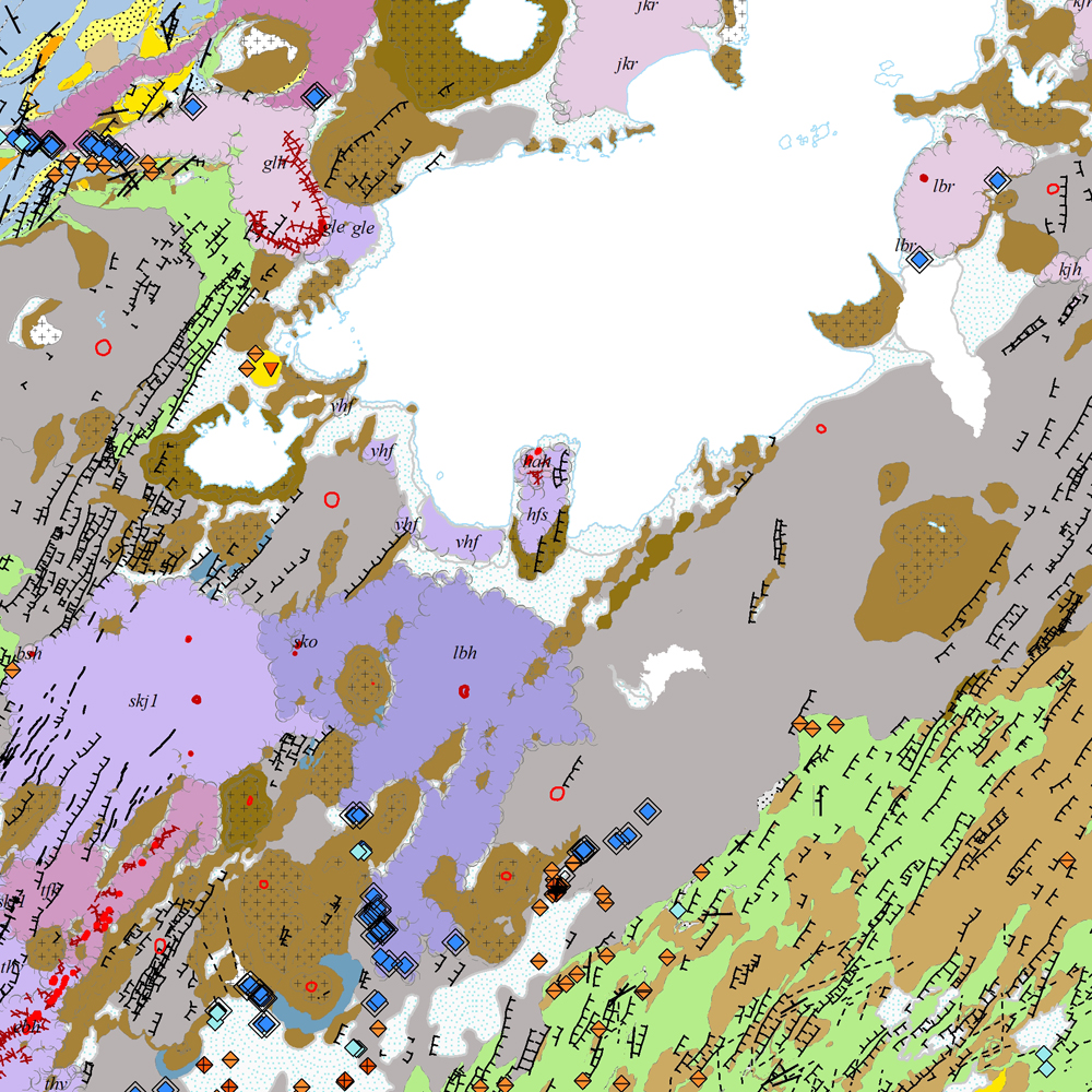
Gagnasafn [GDB] NI_J100v_Vesturgosbelt_1.utg: Jarðfræðikort af Vesturgosbelti Íslands í mælikvarði 1:100.00, 1. útg. [Geological map of the Western Volcanic Zone of Iceland in the scale of 1:100.000, 1st ed.] Kortið sýnir jarðlög, gíga, höggun, strik og halla, framhlaup og niðurföll, steingervinga, jökulrákir, jökulgarða, jökulkembur, malarása og fornar strandlínur stöðuvatna. Jarðlög eru flokkuð eftir aldri, gerð og samsetningu. Kortið var unnin í samstarfi Náttúrufræðistofnunar Íslands og Íslensku Orkurannsoknastofa. Tilvísun: Birgir V. Óskarsson, Ögmundur Erlendsson, Robert A. Askew, Árni Hjartarson, Magnús Á. Sigurgeirsson, Skafti Brynjólfsson og Sveinn Jakobsson 2022. Jarðfræðikort af Vesturgosbelti. 1.100.000. 1. útg. Garðabær: Náttúrufræðistofnun Íslands, Íslenskar Orkurannsóknir og Umhverfis- og Auðlindaráðuneytið. [The map displays bedrock geology, volcanic craters, tectonics, strike and dips, landslides and collapse pits, fossils, glacial striations, glacial moraines, flutes, eskers and ancient lake strandlines. Bedrock is classified by age, type, and composition. The map was completed in a collaborative project between the Icelandic Institute of Natural History and the Icelandic Geosurvey. Bibliographic reference: Birgir V. Óskarsson, Ögmundur Erlendsson, Robert A. Askew, Árni Hjartarson, Magnús Á. Sigurgeirsson, Skafti Brynjólfsson og Sveinn Jakobsson 2022. Geological map of the Western Volcanic Zone, Iceland. 1:100.000. 1st edition. Garðabær: Icelandic Institute of Natural History, Iceland GeoSurvey and Ministry for the Environment and Natural Resources.]
-
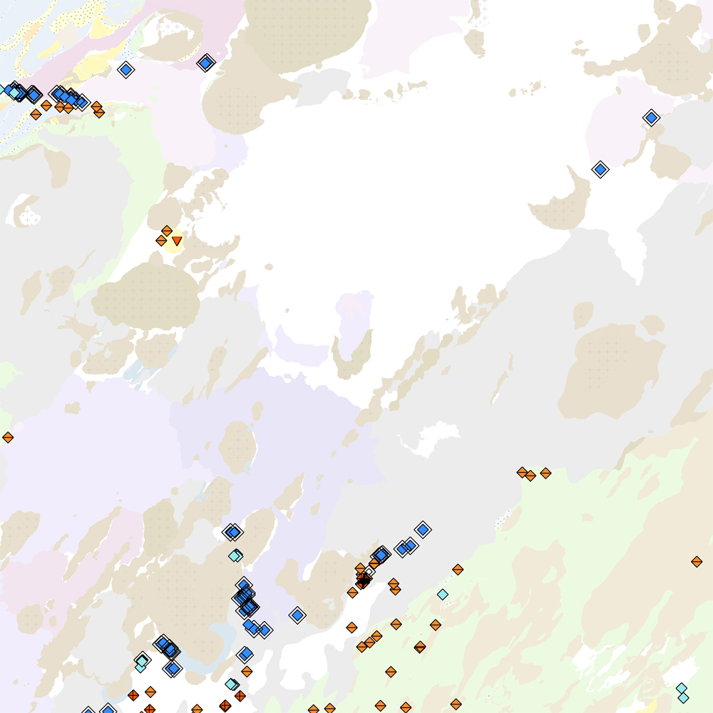
Þekja [layer] j100v_vesturgosbelti_lindir_1utg_p: Lindir og hverir á Vesturgosbelti Íslands. [Springs and hotsprings of the Western Volcanic Zone of Iceland.] Gögnin sýna laug, hver, lindir, gufu- og leirhver. Gögn eru ekki flokkuð eftir ÍST120:2012 staðlinum. Hér er flokkun eða lýsing nýrra fitjueiginda: 'tegUppsprettuISOR': 2: 10–25°C (Laug) 3: 25–50°C (Laug) 4: 50–75°C (Laug) 5: 75–98°C (Laug) 6: 98–100°C (Hver) 20: Hrúður 30: Leir- og gufuhverir 7212: Lindir 10–100 l/s 7213: Lindir >100 l/s 7214: Lindasvæði 100–1000 l/s 7215: Lindasvæði >1000 l/s 'tegUppsprettuNI': 1: Lindir 4: Laug (10–98°C) 5: Hver (98–100°C) 6: Leir- og gufuhver 'vatnshiti': Hitastig vatnsins við lindina, mælieining: °C. 'gerdiISOR': Grágrýtislind/Grágrýtislindir: Lind/lindir í hrauni eldra en síðasta jökulskeið, Hraunalind/Hraunalindir: Lind/lindir í nútímahrauni, Móbergslind/Móbergslindir: Lind/lindir í móbergi, Sprungulind: Lind í sprungu. [This data includes cold, warm and hot springs, steam and mud springs. The data does not follow the ÍST120:2012 data standard. Explanation and classification of the new feature attributes: 'tegUppsprettuISOR': 2: 10–25°C (Warm spring) 3: 25–50°C (Warm spring) 4: 50–75°C (Warm spring) 5: 75–98°C (Warm spring) 6: 98–100°C (Boiling spring) 20: Hot spring deposits 30: Mud and steam spring 7212: Cold spring 10–100 l/s 7213: Cold spring >100 l/s 7214: Cold spring area 100–1000 l/s 7215: Cold spring area >1000 l/s 'tegUppsprettuNI': 1: Cold spring 4: Warm spring (10–98°C) 5: Boiling spring (98–100°C) 6: Mud and steam spring 'vatnshiti': Temperature of the spring in °C. 'gerdiISOR': Grágrýtislind/Grágrýtislindir: Spring(s) in 'grey basalt' lavas older than the last glacial, Hraunalind/Hraunalindir: Spring(s) in postglacial lavas, Móbergslind/Móbergslindir: Spring(s) in hyaloclastite tuff, Sprungulind: Spring in tectonic fissure.]
-
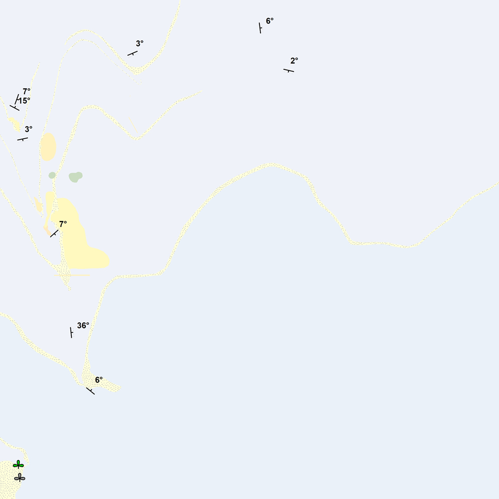
Þekja [layer] j100v_vesturgosbelti_berggrunnur_1utg_p: Steingervingar og strik og halli. [Fossils and strike and dip.] Gögnin innihalda halli, strík og hallaáttir ásamt þekktum steingervingum. Stríkstefna (fitjueigindi 'strikstefna'): 0-359° - fylgir 'right-hand rule'. Hallastefnu eru +90° frá stríksetfna. [The data includes dip, strike and dip directions along with known fossil locations. Strike direction (feature attribute 'strikstefna') follows the right-hand rule where dip direction is +90° from strike.]
-
Þekja [layer] j100v_vesturgosbelti_gigar_1utg_p: Gervigígar, punktalag. [Rootless cones, point data.]
-
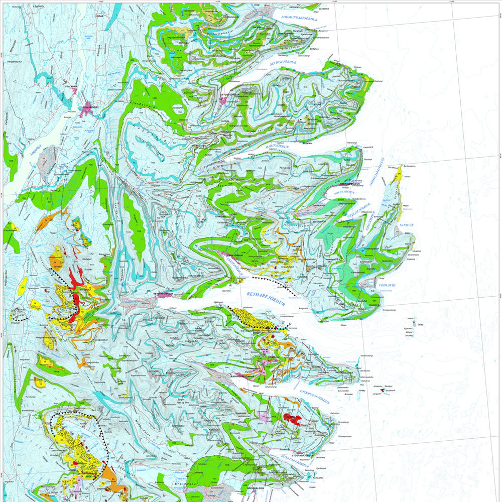
Gagnasafn (GDB) NI_J100v_Austurland_1.utg: Jarðfræðikort af Austurlandi í mælikvarði 1:100.000, 1. útg. [Geological map of Eastern Iceland in the scale of 1:100.000, 1st ed.] Jarðfræðikort af Austurlandi nær yfir svæði frá Berufirði yfir í Mjóafjörð. Berggrunnur er flokkaður eftir gerð og samsetningu. Kortið sýnir túff (gjóskulög), gíga, öskjurima, sprungur, misgengi, strik og halla, framhlaup, steingervinga, lindir og mörk segulskeiðsins C5n. [The Geological map of Eastern Iceland covers the area from Berufjörður up to Mjóifjörður. Bedrock is classified by type and composition. The map shows tuff layers, craters, caldera rims, fissures, faults, strike and dip, landslides, fossils, springs and the base of magnetic chron C5n.]
-
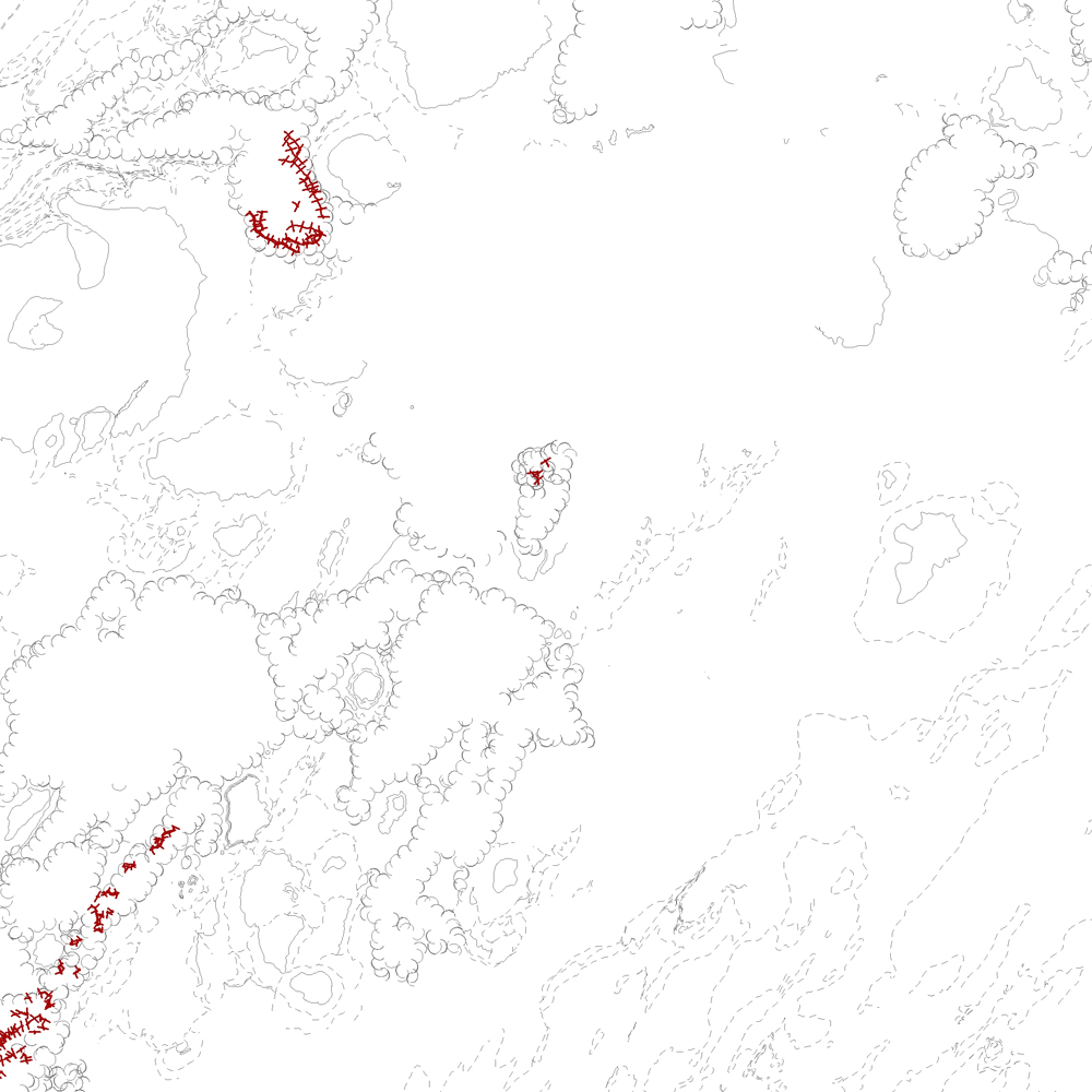
Þekja [layer] j100v_vesturgosbelti_berggrunnur_1utg_li: Línur sýna viss og óviss mörk berggrunns og hraunjaðars ásamt hrauntröðum. [Lines showing certain and uncertain boundaries of bedrock and borders of lava fields, including lava channels.] Mörk tilheyra flákagögnum 'ni_j100v Berggrunnur á Vesturgosbelti – 1:100.000' (þekja j100v_vesturgosbelti_berggrunnur_1utg_fl). Nýr kóði fyrir fitjueigindina 'Jarðmyndun og landmótun lausra jarðefna' (jardmLandmJardefna): hram05 = hrauntröð brún. [Boundaries follow the polygon data 'ni_j100v Berggrunnur á Vesturgosbelti – 1:100.000' (layer j100v_vesturgosbelti_berggrunnur_1utg_fl). New code for feature attribute 'Jarðmyndun og landmótun lausra jarðefna' (jardmLandmJardefna): hram05 = lava channel edge.]
-
Gagnasafn (GDB) NI_F25v_mikilvaegFuglasvaedi: Flákalag. Alls er 121 svæði á Íslandi sem telst alþjóðlega mikilvægt fyrir fugla. 70 svæði teljast til sjófuglabyggða (SF), 25 svæði eru fjörur eða grunnsævi (FG) og 31 svæði er votlendi eða önnur svæði inn til landsins (VOT). Nokkur svæði falla undir tvo eða þrjá flokka. Mikilvæg fuglasvæði er að finna í 65 af 74 sveitarfélögum landsins. Afar misjafnt er hversu mörg mikilvæg svæði eru skilgreind fyrir hverja fuglategund. Hjá varpfuglum eru langflest svæði skilgreind fyrir fýl (38) og hjá fargestum eru þau flest fyrir rauðbrysting (átta svæði). Fyrir 40 tegundir hafa engin mikilvæg svæði verið skilgreind. Alþjóðleg töluleg viðmið hafa ekki verið sett fyrir 21 þeirra en hinar 19 eru það fáliðaðar hér á landi að engin svæði teljast alþjóðlega mikilvæg fyrir þær. Kóðar fyrir fitjueigindir ‚Staða fitju‘ (stadaFitju) eru: 0 = ekki skilgreind áður sem mikilvæg fuglasvæði; 1 = skilgreind áður sem mikilvæg fuglasvæði, útlínur notað; 2 = skilgreind áður sem mikilvæg fuglasvæði, útlínum breytt; 3 = skilgreind áður sem mikilvæg fuglasvæði, útlínur NÍ; 4 = friðlýst, á náttúruminjaskrá eða votlendisskrá (getur auk þess verið skilgreind áður sem IBA), útlínur notað; 5 = friðlýst, á náttúruminjaskrá eða votlendisskrá (getur auk þess verið skilgreind áður sem IBA), útlínum breytt eða búið til; 6 = svæðið er hluti af öðru svæði sem er friðlýst, á náttúruminjaskrá eða votlendisskrá (getur auk þess verið skilgreind áður sem IBA) eða hluti þess er friðlýst, á náttúruminjaskrá eða votlendisskrá (getur auk þess verið skilgreind áður sem IBA), útlínur NÍ. [A total of 121 IBAs are defined. 70 IBAs are seabird colonies (SF), 25 IBAs are primarily intertidal zones and adjacent shallow marine waters (FG), 31 IBAs are inland, predominantly fertile wetlands and surface inland waters. A few IBAs fall under two or three categories. These IBAs lay in 65 of the 74 municipalities of Iceland. The number of IBAs designated for each species varies; by far, most breeding sites of Fulmarus glacialis (38). No areas were designated for 40 species. For more than half of those IBA-criteria have not been defined; others do not meet the criteria due to their small populations in Iceland. The feature attribute codes for ‘stadaFitju’ are: 0 = not previously designated as IBAs; 1 = previously designated as IBAs, outline unchanged; 2 = previously designated as IBAs, outline changed; 3 = previously designated as IBAs, outline drawn by IINH; 4 = protected or on the Register of areas of conservation interest (could as well be previously designates as IBAs), outline unchanged; 5 = protected or on the Register of areas of conservation interest (could as well be previously designated as IBAs), outline changed; 6 = .area is part of an area that is protected or on the Register of areas of conservation interest (could as well be previously designated as IBAs) or part of this area is protected or on the Register of areas of conservation interest (could as well be previously designated as IBAs), outline drawn by IINH.]