 Lýsigagnagátt

Type of resources
Available actions
Topics
INSPIRE themes
Keywords
Contact for the resource
Provided by
Years
Formats
Representation types
Update frequencies
status
Service types
Scale
Resolution
-

Í gögnunum er að finna upplýsingar um staðsetningu og umfang friðlýstra minjasvæða á Íslandi sem Minjastofnun Íslands hefur friðlýst í samræmi við lög nr. 80/2012 um menningarminjar.
-

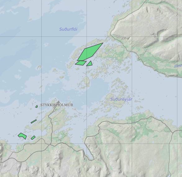
Upplýsingar um eldissvæði í sjókvíaeldi sem eru í umsóknarferli hjá Matvælastofnun.
-

Land og skógur, skoðunarþjónustur (áður Skógræktin).
-

Skoðunarþjónustur Minjastofnunar
-
Skoðunarþjónustur Mast
-
Skoðunarþjónustur Fiskistofu
-
Ræktunarsvæði er afmarkað svæði sjávar nægjanlega stórt til að rúma þann ræktunarbúnað sem notaður er á viðkomandi svæði. Yfirleitt er um að ræða línur sem strekktar eru á milli flot bauja eða sérstaka ræktunarfleka með lóðréttar ræktunarlínur fáeina metra niður undir yfirborð sjávar . Svæðið er merkt með löglegum sjómerkjum þannig að sjófarendur eiga að geta varast þau, enda einnig merkt inn sjókort Landhelgisgæslunnar. Einungis er ræktuð Bláskel (Kræklingur).
-

Land og skógur, niðurhalsþjónustur (áður Skógræktin).
-

Skoðunarþjónustur Ferðamálastofu
-
Niðurhalsþjónustur Landhelgisgæslu Íslands